Archanglos to Stegna and beyond to Tsambika
A linear walk taking in the coastal section of Rhodes from Stegna to Tsambika
This coastal walk of discovery finds an accessible route from Stegna to Tsambika. This is predominantly of dirt tracks although there are some steep inclines. This has some amazing coastal scenery with plenty of opportunities for refreshment breaks at Stegna and Tsambika beach. A great walk. The ends of this linear route are linked by the regular bus service.

Walk Statistics
- Start location: Archangelos
- End location: Tsambika
- Distance: km ( miles)
- Total Gain: metre ( ft)
- Total Descent: metre ( ft)
- Min Height: metre ( ft)
- Max Height: metre ( ft)
- Est. Walk Time:
- Walk type: Linear
- Walk Grade: Easy to navigate
- Terrain: Dirt tracks, asphalt roads
- Obstacles: There is nothing too demanding throughout this walk.

Maps
The following maps and services can assist in navigating this route. There are links to printed maps and links to downloadable GPX route data for importing into navigational software and apps.
- GPX Route File
Accommodation
Pefkos Blue Studios, PefkosapartmentView in Google Map
- Website
- https://www.pefkosbluehotel.com/
- Description
- Pefkos Blue formerly known as Dimitri Studios, offering self catering apartment studios overlooking Pefkos village with splendid views across the bay. This is probably the best place in Pefkos if you want to be away from the village. Above the hubbub it offers unrivalled views and a quiet location.
Transport
Rhodes Public Transport - Bus Service
- Service Details
- Gennadi to Rhodes Town - KTEL Rhodes Public bus service serving the East Coast of Rhodes linking Gennadi, Kiotari, Lardos, Pefkos, Kalathos, Archangelos, Afandou, Faliraki and Rhodes Town
- Timetable
- https://www.ktelrodou.gr/
Walk Notes
This is a walk that we had put off for a number of years. There were several reasons for this delay, the principle one being reports that there was no longer access to Stegna from the tracks and lanes out of Archangelos. In fact, back in 2014 we had walked the road down into Stegna in a hope of finding the return route up through the tracks above the village. Our only guidance was the written directions within a printed book and we failed to find the track out of the village. Subsequently an online resource stated that the route had been blocked up which was maybe why we were unable to find it. Despite this, Googles current aerial imaging depicted possible access into the village from the tracks and a route was suitably plotted, with alternative options if the primary access was blocked up.
In addition to gaining access to Stegna, we also wanted to determine if it was possible to walk from Stegna, along the coastline to Tsambika beach. This is something that no-one seemed to be able to provide us with a definitive answer and the Google aerial images also left a lot of doubt as to its feasibility. The only way to answer these questions was to go on an adventure and find out for ourselves. Even if we had to return to Archangelos by road or have to retrace our steps, then nothing is lost, knowledge is gained and the experience is worth the day out.
We start in Archangelos. The buses to Rhodes town pass through here and the intrepid adventurer needs to alight at the principle stop on the eastern side of the main shopping street. This stop is named Archangelos School (ΑΡΧΑΓΓΕΛΟΣ ΣΧΟΛΕΙΟ
) and is by the paved area where two busts atop plinths and there is a monument with an embossed sculpture of a figure wielding a sword above his head, presumably this is Archangel St Michael whom the towns name is derived from.
The route out of the town takes the road opposite the paved area that follows the river where a road sign points to Beach Stegna
. This is the main road that runs down to the village and once out of town becomes a modern highway. We briefly follow this before branching off to the right and through the housing at the boundary of the town and onto a surfaced lane through the countryside. Beyond the buildings are olive groves on either side. The castle ruins can be seen on the left atop a rocky hill, and ahead are more mountainous rocky hills.
We soon reach a fork in the track, with the main route taking the right branch which descends down a gradient and is the route we take for this walk. The left branch is a possible alternative and leads to a footpath that descends a steep rocky hillside to Stegna. We have not walked this and therefore cannot validate its accessibility. That will be another walk on another visit.
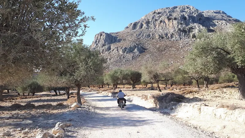
The incline past the branching tracks is concreted. A lot of inclined tracks around this area have been surfaced for the length of the slope. We can only assume this is to aid better traction for vehicles. The tracks are no more than dirt tracks with plenty of loose gravel and stones. Having said this, other than the odd moped, vehicles are seldom encountered and it is easy walking and a pleasure to be out in the wilds with just nature as company.
As we wandered onwards, admiring the views, the sound of one of these puttering mopeds could be heard behind us. We looked around to witness a battered old bike so typical of rural Rhodes. It seems it is a ubiquitous method of the humble Rhodian smallholder to get around, it does its job and there is never any haste to get to ones destination. In this instance the moped was being driven by an old man, his headgear no more than an old baseball cap shading a sun weathered face, and his body perched on the saddle, wearing loose shirt and trousers. He slowly steered the machine around the pot holes and rocky obstacles at a pace barely above walking. He pulled up alongside us with the customary Kalimera
followed by some Greek words before he attempted to practice a little English but with a very limited vocabulary. This character was familiar. Stamatis?
the question was posed to him. Stamatis was name of the caretaker at the church of Virgin Mary Our Lady Epakousa (Παναγία Επακούουσα Panagia Epakousa) which sits alongside this track. We had met him the year before whilst walking between Archangelos and Haraki when he invited us into the chapel and sang and prayed for us. It took a few seconds before he recollected our faces and Greek words accompanied his smile of recognition. Then off he went, dodging the potholes ahead of us with a putt putt putt.
It was another 1 km of walking through this landscape before we passed Stamatis' Chapel. His moped sat outside under a tree, alongside a car. A shiny modern car. Evidence that we could only guess was another customer for his singing and praying. We passed by.
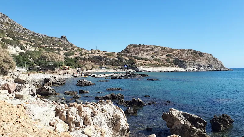
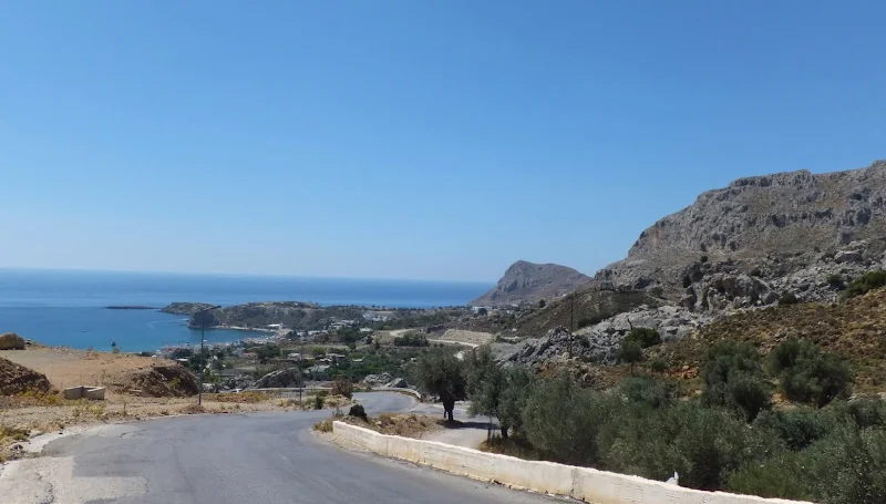
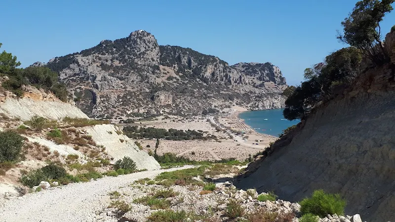
Beyond the chapel the road descends steeply, and once again the surface has been concreted. The first time we walked this many years ago it was gravel and very easy to loose ones footing on the loose surface. Loose surfaces are great for goats, but a hazard for us bipeds. At this point, the coast becomes visible in all its glory. These views make it all the worthwhile of walking down these tracks.

At the bottom of this hill we take a left and follow a steep ascent, once again surfaced. The track soon levels out to reveal a coastal panorama, all the way past Feraclos castle above Haraki and out to the Lindos peninsular. To the north are a series of bays, Stegna hidden from view in once of these. Beyond is the Tsambika coastal mountain where the Tsambika monastery perches on its summit. Beyond this is another rocky hill which masks Antony Quinn beach, and on which is said to be the scant remains of an old castle by the name of Eriokastro Ερημόκαστρο
.
Looking directly ahead to the coast is a small craggy hill which is named Κούμελο
on the Orama Map. The Latinized name is Koumelos. This, I would guess, is the location of the Koumelos Caves, renowned for their impressive stalactites. The caves are listed on many tourist websites and in tourist literature but in all cases there is no specific direction as to their location. The best instructions are no more than a vague description of a small hill on the road from Archangelos to Stegna. If this track was considered the road into the original old fishing village of Stegna, then this would certainly fit the bill. Any tourist trying to locate the caves with the cryptic clues as to their whereabouts would most likely result in disappointment when attempting to find them on the modern road into the present day village. It certainly took me a considerable amount of research to deduce that this remote hill is their most probable location. This is the beauty of walking as one immerses oneself into the landscape and the questions of landmarks arise which can then be researched.
Maybe the caves' illusive location is a good thing. In addition to their impressive speleology is the fact that they are also the source of some unique archaeological discoveries during the late 1970s. I am led to believe from the scant resources thus far found, that excavations in the caves revealed artefacts dating from The Late Neolithic and Minoan area, 4500-3000 BC, and are some of the oldest evidence of human civilisation on Rhodes, and indeed in all of Greece. Take a moment to take such antiquity into perspective. That is six and a half thousand years old. 6500 years. That is some 1500 years older than Stonehenge in England. The discovery was hidden under many layers of volcanic ash from the eruption of Santorini which occurred sometime around 1600 BC, and the finds included an ancient Minoan Vase.
For those interested in the caves there is an online video which records a guided tour conducted by geologist Vangelis Kambouroglou who was involved in the excavations. The video is spoken in Greek with no subtitles but provides views from within the caves which speak for themselves. It would seem these tours ceased some years ago and currently there are no excursions to the caves.
More images from inside the caves can be seen on the Greek News Website Rhodes Report. This specific news story highlights the vandalism that has been wrought upon the caves by visitors. It states that many visitors are breaking off the stalactites as souvenirs. These take centuries to form and with the caves not curated and being open to anyone who passes by, are consequently abused to the detriment of others who may want to visit. In addition, a photo of one of the cave entrances taken by a hiker in 2019 appears to show that this is now guarded by metal fences. This is unfortunate for visitors but maybe best for the natural beauty of the caves. The only way to find out more information is to visit, something that we may well do on a subsequent visit to the island.
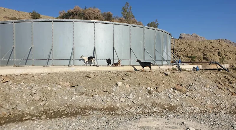
We draw ourselves away from this magnificent panorama, past what looks like a large metal reservoir where several goats casually lounge about the concrete base. This was certainly not a flock or herd, and given their few numbers such a gathering of caprine beasts could not be described by other collective nouns such as a tribe or drove. After a little more research, a much more appropriate collective noun for this small gathering was discovered, a trip of goats. I like that. A trip of goats. They nonchalantly watch us pass, probably mulling over the collective noun for just two wandering humans. As goats are unable to peruse documented sources for collective nouns, maybe they would use conjecture. A perambulation of humans? That would certainly describe our unexpected meeting on these remote tracks.
The track descends steeply to the first signs of civilisation of Stegna, once again surfaced before continuing along the flat ground below on a gravelled dirt track. It was here that we encountered a couple wandering in the opposite direction, and obviously tourists, certainly not locals as could be seen from their attire. They plodded slowly towards us, obviously out for a walk or some kind of mission of discovery yet they were not dressed to what one usually expects of walkers. They wore shoes rather than walking boots, the man had socks over his trouser legs and the lady had her hidden under some fancy shade that was not exactly a hat. This gave the impression of some Victorian explorers casually walking with no urgent pace. They stopped to speak in English, the accented inflections not disguising the fact that were of German extraction. There were little in the way of pleasantries as the man got straight to the point in asking for the directions to Haraki. I provided them the knowledge of our experience, both the simple route via track, and the cairn led route that follows the coastline. They wanted the path, the rocky route following cairns, the most beautiful yet the most challenging. In return they informed us that there was access into Stegna as that is where they had started from. They went their way. We went ours.
The route into the village was as I had mapped out from viewing the aerial images. This is a little difficult to describe, and is not immediately obvious when walking along the track. Some 250m after the concrete track ends, where the dirt track bears around to the left, there are some buildings on the right, together with some chain-link fences and some vacant scrub. A track leads into these grounds, appearing to be no more than access to these private plots of land. Despite this, take the track, soon branching off on a well trodden footpath to the left and through the scrub. It initially appears to be blocked by one of the fences, but persist in following this and it leads around the side of a fence and out onto a road. Turn right onto the road and this leads down to the seafront. There may well be other routes into the village but this was the one that we had planned.
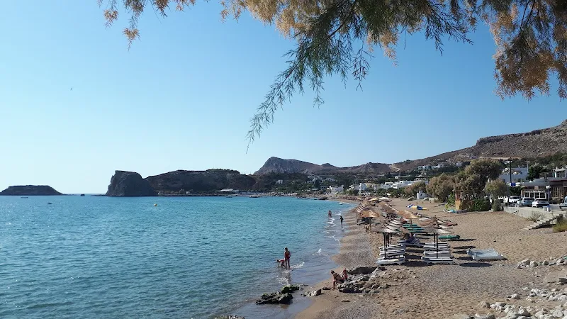
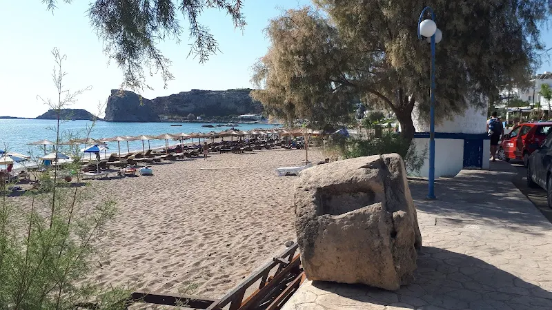
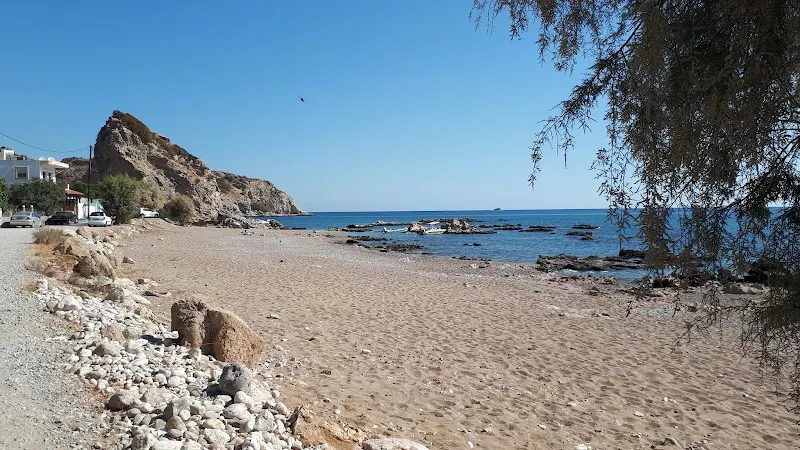
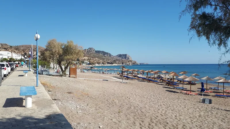
Up until more recent times, Stegna was no more than a fishing village and part of the municipality of Archangelos. In those days at the start of the 20th century, the village comprised of little more than a handful of isolated houses. These days it is a vibrant seaside resort dedicated to the tourist industry albeit still retaining a village peacefulness. Tourist literature compliments the village for its beaches and tavernas and it would appear to be a popular destination for German tourists. There is a short sandy beach that follows the long curving bay, with an abundance of regimentally set out sun loungers. A pavement abuts the beach and is laid out with blue posted lamp posts that have globe light fixings and every 15m a blue seated bench provides opportunities to sit and take in the deep blue seascape. A road follows the pavement and is lined with a myriad of restaurants and tavernas intermingled with small guest houses and other accommodation.
On this October morning there was few folk around. The beach was empty of sun seekers, the tavernas were empty and it was difficult in some instances to determine from their vacant facades and seating whether they were yet to open for business or were just awaiting custom. For us walkers casually parading down the prom, it made a difficult choice to deduce what taverna to visit. Eventually we chose one where there was someone sitting by the bar waiting for custom. This provided a good choice with shade, views of the beach and a long cold frappe to while away some time before the next part of the adventure.
This taverna was almost opposite a small windmill type building that sat beside the prom, no more than 3m in height. Painted in the traditional Greek colours of blue and white the circular housing was constructed upon a rectangular base with steps up to the door. Its traditional Greek sails faced the sea and were almost hidden from view unless one walked along the beach. A thick old millstone was placed on the pavement beside the mill, circular and well worn with all the appearance of having been worked for centuries of milling. There is nothing to deduce the age of the windmill, or its history. A brief passing by this structure one may easily conclude that it is no more than an ornamental curiosity or folly but on closer study of its stonework it seems to be the real thing.
The next item on our itinerary was to try to find a route through to Tsambika beach. The big issue here was a large rocky cliff that straddled the coast with no clear route to get over or around it. Aerial views from Google certainly depicted tracks, but these were on the higher ground above the northern beach and there was no way up to them other than rock climbing. Another cove beyond offered a track up to the top, but this was separated by a large rocky outcrop with no beach to get around it. The taverna owner came over to offer some conversation and gave us the opportunity to ask for a little local knowledge of how to walk to Tsambika. He immediately told us there was no route other than to follow the road to Archangelos and then follow the main road. He then amended his instructions to detail a road that would offer a shortcut to further along the main road. The only alternative was to swim. This did not sound promising.
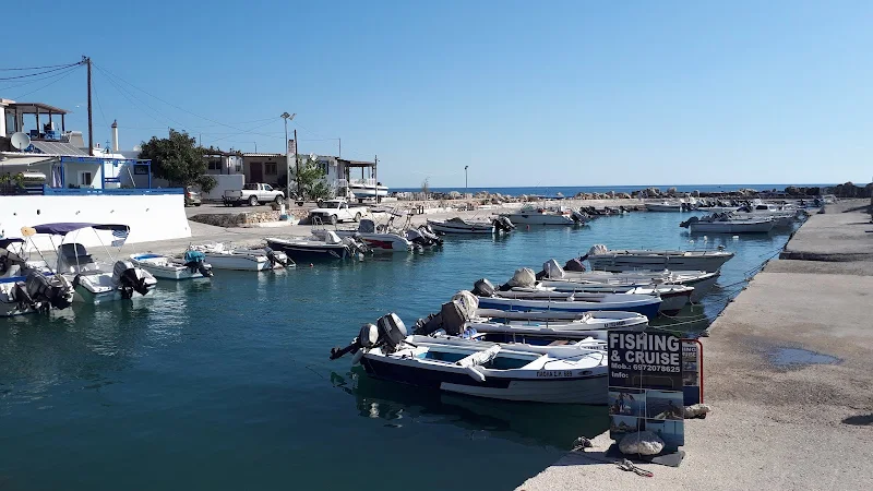
We paid our bill and left the taverna to wander up to where the beachside road turned inland to head back to Archangelos. A small picturesque harbour exists at this point, with its side populated by a long line of motorboats. A flush of ducks played at the head of the harbour where waters trickled out from a channel under the road. It was at this point that we had to contemplate a decision. If there was no route to Tsambika other than the road, then walking the main road was not really something worth considering. That would mean we would have time on our hands, therefore there was nothing to stop us from exploring the northern beach.
So off we went, to discover the more secluded beach where a road continued along the seafront. This was certainly not as commercially oriented as the main beach with much less tavernas although the start of the beach was still paraded with sun loungers. The road around this more private bay was lined with guest houses although these had a much more rustic appeal to them than those in the main village. At the far end of the beach was a large rocky outcrop, the obstacle that prevented further exploration north of the beach. This rocky headland is labelled as Ακ. Συριακή
on the map. I am unsure of the abbreviation Ak. but it does appear next to many headlands on the maps and therefore I would conclude this must be an abbreviation for a geographic feature. What ever this was called it was a huge cliff faced rock that protruded out into the ocean to provide a northern limit to the beach. It was somewhat separated from the main cliff, but beyond that was more huge cliff faces bounded by the waters.
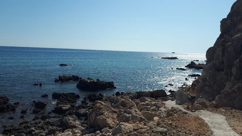
We continued walking towards this rock, taking in the sights of the beach. Guest houses sat in the shadow of the huge cliff that presented no access inland. The further we wandered the more rustic these buildings became, and the fewer signs of life presented itself. A young couple passed by us on a moped stopping just short of the rock. They alighted the machine and started to walk towards the rock. It soon became apparent there was a walkway between the rock and the main cliff. That was worth investigating although we knew that there was a more obstacles beyond. Another couple walked back out from this walkway whom had walked in just a couple of minutes earlier. We followed the moped couple through the gap and into a small rocky bay. From here there was a clear trodden path on the pebbles to where the next rocky cliff protruded into the waters beyond. This path led onto a makeshift concrete path that filled the gaps between the rocks and led around the bottom of the cliff that formed the headland. At this point, the moped couple turned back, and other tourists who had followed us also turned back. We were now on our own, heading into a secluded little bay, devoid of tourists.
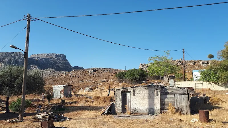
This bay held a rocky beach with a few old houses around its short length and absolutely no sun loungers and no sign of tourist amenities. Trees stood around the track providing soothing shade. This looked to be a working fishing hamlet, it was obviously inhabited by local Greek folk and looked well lived-in. A step back in time to what much of the coastal villages must have once looked like. A pickup truck sat alongside the track that bordered the bay and that was the evidence that there must be some way out of the bay with vehicular access. After initially wandering around the bay for the sheer pleasure of taking in this rustic place we returned to find the way out. A couple of small dogs pestered for attention and a woman crossed our path offering a Kalimera
. We got back to the pickup truck and discovered a track that led up behind the houses, rising steeply out of the bay.
At the top of the initial ascent the track twisted on a hairpin bend to rise at a lesser rate. On this bend a work crew with JCBs stood chatting. Kalimera!
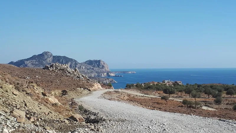
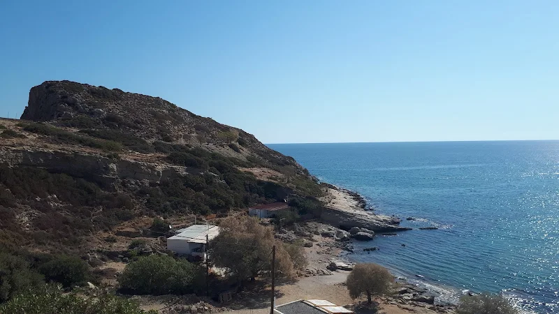
. They seemed somewhat surprised to witness the two of us walking along this track. The track rose more, and soon we had risen some 100m above the cove. This now all looked promising. The route I had plotted would then take a track through to Tsambika beach, a track not marked on maps but was clearly visible on Google aerial photos. This track branched off just past a cliff face that scarred the land diagonally to the coast. At the point the track we were walking met this cliff, the track to Tsambika presented itself off to the right. It was certainly not conducive to vehicular access other than the sturdiest of off road types. The track looked like it had been deliberately cut through the mountain and slowly curved around descending towards the flat area of land that was fronted by Tsambika beach. The first view of the beach down below was exhilarating just for the fact that we had nearly completed our expedition of discovery.
The descent was fairly steep and the track was full of loose rocks, pebbles and gravel that shifted under ones feet with each step. On the left a deep channel had been cut, obviously to channel water down the hill. The view ahead was amazing, a broad plateau that linked the hills we were now descending and the huge mountain ahead where Tsambika monastery could clearly be seen on its summit.
At the bottom of this descent the track turned into a dirt track that traced a straight route across the plateau to emerge close to the junction of the Tsambika road junction with the national road. Rather than taking this, we found a winding route across the scrub and dunes to the beach. It would have been more fitting to find a secluded Greek taverna to have lunch but the ambition of the days plan was to link this beach and Stegna which we had achieved. Therefore we headed across to the beach to have lunch at one of the beach kantinas. A beer and a Greek salad was enough to celebrate the days successful adventures and reflect on all that we had seen and experienced.
The end of the days walk was following the road out to the national road. It wasn't until getting to the head of this that we found a number of tavernas lining the road which may have been more appropriate although they were all geared towards the constant passing tourists that were heading to the beach.
There is a bus stop directly opposite the junction on the national road which will take one back to Archangelos and onto Lindos and Pefkos. This has a bench in the shade of the trees which made it a pleasant experience waiting for the next Pefkos bus.
Directions
Tracks from Archanglos to Stegna, then coastal walk to Tsambika beach
Take the road that is signposted for Stegna Beach at the eastern end of Archangelos adjacent to the river bridge. Follow the road for 175m where it branches. Take the right hand branch up the hill, following the road as it curves around. At the junction bear round to the left and follow this out of the town and into the countryside. Where this branches, follow the main track on the right. Eventually this will pass a chapel on the right and the track will descend on a concreted section of road. At the bottom of the hill take the left which will lead round to a steep ascent before turning to follow the coastline. Keep to this track ignoring all others. This will descend down a concreted road. After the concrete end, continue on the dirt track for a further 250m where the track bears left. Continue off to the right, following a track into what loks like some homestead and then take a footpath on the left through the scrub. This will lead up to a chain link fence and then follow this to emerge onto a road. Turn right and follow the road, keeping to the tarmac as this descends down the hill to the sea front. Continue through Stegna following the beach. At the far end continue straight ahead, past the harbour and onto the beach beyond. Keep to the track to the very end where there is a large cliff. On the landward side the cliff is detached from the main cliff and the is a path between the two. Follow this continueing on the well trodden stones to the cliff edge by the sea of the next headland. A path leads around this and joins a concrete path across the rocky bay to lead into the next bay. There is a track out of this bay that goes behind the houses and up the hill. This makes one hair pin bend then ascends some more as it slowly curves around inland. It passes a building then continues to head for a gap in the hill. At this gap there is a rough track on the right. Take this. It descends down to the valley below which is fronted by Tsambika beach. The track will continue on to the main road, but for those wanting the beach there are tracks across the scrub and dunes to the beach. Access to the main road is then following the road out from the beach. The bus stop is directly opposite the road junction.
Image Gallery


Route Validation Cards
Validation Date - 2021-10-08
- Time of Walk: 09:30 to 14:30
- Validators: Griffmonster, Kat
- Weather Conditions: Very warm but overcast day
- Notes: Initial route undertaken
Summary of Document Changes
Last Updated: 2026-03-30
- 2021-11-21 : Original publication
- 2021-12-01 : Removal of ViewRanger links due to its imminent demise
- 2026-01-12 : Major website update with all walks recast to the new format


1 comments:
The flexibility of stay durations, coupled with competitive rates and promotional offers, allows for budget-friendly options without compromising on quality. Plus, the prime location provides easy access to local attractions and transportation, making it a practical choice for both short and long-term stays. Learn more details from this website and experience a hassle-free booking.
Post a Comment