In Search of the Cave Chapel of Agathi Beach

An easy 5 mile walk around Haraki and Agathi Beach
The simple and easy walk leads across the flat landscape around Haraki to go in search of a Cave Chapel that exists at the end of Agathi Beach. This historic cavern dates from at least the medieval period and is a treasure to behold. Along the way there are other chapels and features to inspire ones curiosity.

Walk Statistics
- Start location: Masari Main Road
- End location: Malona Main Road
- Distance: km ( miles)
- Total Gain: metre ( ft)
- Total Descent: metre ( ft)
- Min Height: metre ( ft)
- Max Height: metre ( ft)
- Est. Walk Time:
- Walk type: Linear
- Walk Grade: A fairly flat terrain
- Terrain: Tracks, country lanes
- Obstacles: The route out of Agathi Beach requires crossing a broken down fence. If this fence is reinstated return to the start of the beach and turn right and follow the track through

Maps
The following maps and services can assist in navigating this route. There are links to printed maps and links to downloadable GPX route data for importing into navigational software and apps.
- GPX Route File
Accommodation
Pefkos Blue, PefkoscampsiteView in Google Map
- Website
- https://www.pefkosbluehotel.com/
- Description
- Pefkos Blue, aka Dimitri Studios, Pefkos offering self catering apartment studios overlooking Pefkos village with amazing views across the bay
Transport
Rhodes Public Transport - Bus Service
- Service Details
- Gennadi to Rhodes Town - KTEL Rhodes Public bus service serving the East Coast of Rhodes linking Gennadi, Kiotari, Lardos, Pefkos, Kalathos, Archangelos, Afandou, Faliraki and Rhodes Town
- Timetable
- https://www.ktelrodou.gr/
Walk Notes
This walk was one of discovery. A casual remark after a previous years walk about the existence of a cave chapel located somewhere around Agathi Beach left the compulsion to research where this was located and then to go and explore. The issue with finding such unique places are that they are not well documented in tourist guides or marked on local maps. It took some on-line research to merely discover an image, let alone its location other than it was in the vicinity of Agathi beach.
Therefore on a 2019 October morning we set out with a full day to explore and discover. As with all Griffmonster Walks, this had a pre-plotted route although it was open to customisation at any point. The result was the route documented here which encompasses a whole lot more than just the chapel that we set out to discover.
The walk starts at the roundabout junction where the Route 95 Eastern highway intersects with the road into Masari and the back road into Haraki. There is a bus stop here and a request to the KTEL bus driver to stop at the Masari Main Road stop will get you to the correct destination. On the Masari side is a small Kantina where one can take a drink and snack for breakfast before setting out on the walk. This is a typical Greek cafe where folk sit and talk and take advantage of the shade and it is certainly not a tourist hotspot which is something to really appreciate when visiting Rhodes.
On the opposite side of the highway is the back road into Haraki which can easily be walked without confronting a lot of traffic and is the easiest way to get to this small coastal resort without a car. It is only a 10-15 minute direct walk and can be achieved by anyone of moderate fitness. However, for this wander we will take a more leisurely meander through the countryside. To the left of the Haraki road as seen from the Kantina, is a surfaced track that leads down to a building. Taking this, veering right past the house, one is soon out into the wilds surrounded by myriads of olive groves, abundant in a thick crop in this particular year. The track twists and turns through this flat landscape until it comes to a chapel set in a courtyard and bordered by a wall, which sits on a rise in the ground, making it visible from some way off.
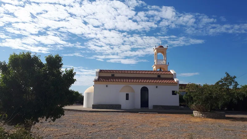
The Chapel is dedicated to Saint Panteleimon, ( Άγιος Παντελεήμονας ), reputedly a Christian healer from Nicomedia in the ancient Kingdom of Bithynia, part of modern day Turkey. This period of the 4th century saw the persecution of many Christians authorised by the Roman Emperor Diocletian and such a fate was met by Panteleimon in the year 305 AD. The legend associated with his martyrdom reads like a Dick Dastardly or Roadrunner cartoon where no matter what method his persecutors employed to destroy him, he always managed to escape. They attempted to burn him with flaming torches but their fires were miraculously extinguished. They attempted to put him into a bath of molten lead but the lead cooled and became solid before they could immerse him. They then threw him into the sea, weighted down with a heavy stone but the stone miraculously floated, presumably a bad choice of stone. They threw him to wild beasts but he blessed them and they peacefully departed without a snarl or growl. They tied him to a large wheel, a common method of punishment and execution known as the Catherine wheel but the ropes that secured him snapped. They tried to be more straight forward and simply behead him with a good old fashioned sword but the sword bent. It really was not a good day for persecutors and Panteleimon must have felt extremely sorry for his assailants as the legend states that he eventually willed for a beheading to occur and they successfully managed to perpetrate their murderous deed. It is said a lot of people were converted to Christianity after witnessing these miraculous escapes.
The chapel is an impressive building in comparison to its humble landscape, with a tiered pitched roof and three tiered bell tower. It appears to be a modern structure but unfortunately on this occasion the gates were firmly secured and we could not gain entry.
The tracks emerge from the olive groves and scrub-land past holiday apartments and onto the road that leads into Haraki. After a few yards it meets the coast and turns a sharp left to follow the shoreline. The shingle beach is known as Masari Beach even though the town of the same name is some miles away. To the right of the bend, is a small chapel that looks out diagonally across a basketball court. An odd scene in this part of the world by all means. The court looks unused and is bordered by decaying single storey buildings. The hollow building on the far side has nothing more than a skeletal structure for a roof and the adjacent buildings are in little better condition. Small heaps of debris scatter the ground and vegetation is left to run wild. Behind the chapel, looking out to sea, is what looks like a bunker with camouflaged metal doors loosely ajar and heap of earth across its roof.
The Chapel is a contrast and looks well kept and still in use, its bright white walls and blue curved roof stand out against the neglect all around. Above the chapel door are Greek lettering in two lines ΙΕΡΟΣ ΝΆΟΣ ΆΓΟΣ ΝΗΦΩΝ ΆΓΟΣ ΑΗΗΤΙΟΣ
. I have been reliably informed by a reader that this translates as Holy church of Saint Nefon and Saint Demetrios
. Nefon, more formally known as Nephon II of Constantinople, was born on the Peloponnesian peninsula in southern Greece during the 15th century to a Greek mother and an Albanian father. During his lifetime he became the Ecumenical Patriarch of Constantinople three times and he passed away at the Monastery of Dionysiou on Mount Athos in 1508 after which he was canonised into sainthood. Demetrius of Thessaloniki was a 4th century martyr and was also known as the Holy Great-Martyr Demetrius the Myroblyte. The word Myroblyte, often referred to as Myrrh-flowing, Myrrh-streaming or Myrrh-gushing is the reputation that the Saints' relics or icon exudes the aromatic aroma of myrrh.
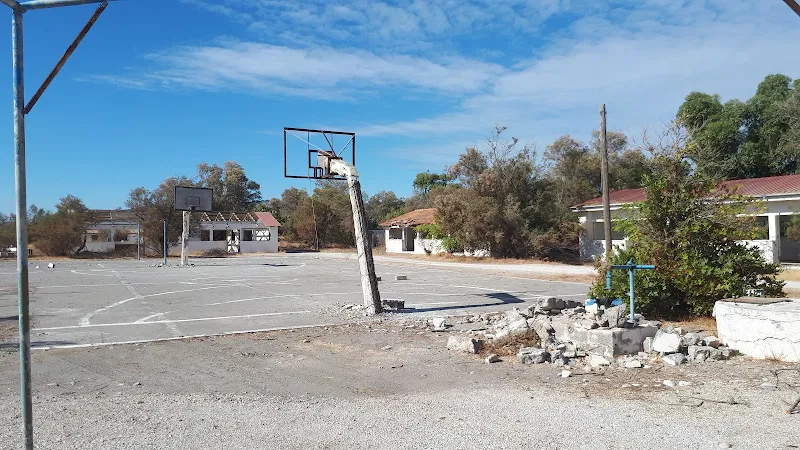
This curious sight does make one wonder about its history. What was this area used for? Why was it left abandoned? It takes a some research to find even the minimalist of information and then we have to refer to Greek internet sites that contain memories from years gone by. Such on-line references reveal that back in the 1960s this was a children's holiday camp that would offer Greek school-kids and underprivileged children the chance of Summer's holiday, one writer describing the place as a Rhodes' institution
. Many happy memories and times were forged here until it was abruptly closed as a holiday camp in July 1974 and occupied by the Greek Army. This appears to not have been a casual exchange of use but an immediate evacuation of schoolchildren and military takeover. This coincides with the Turkish invasion of Cyprus which no doubt caused nervousness by the Greek authorities that the Turks would also attempt to invade Rhodes.
The military camp subsequently became known as the KEPM Harakiou Safety Engineering Training Center (ΧΑΡΑΚΙΟΥ ΚΕΝΤΡΟ ΕΚΠΑΙΔΕΥΣΕΩΣ ΠΛΩΤΩΝ ΜΗΧΑΝΙΚΟΥ
), and a sign proclaiming such stood outside the camp for many years. It is uncertain exactly when the army left and the area became derelict but this probably occurred in the early 2000s, no doubt caused by the Greek financial crisis. These days it is often referred to by tourist guides as the former army camp with little other information. But it was so much more than an army camp to a whole generation. It was a magical summer camp laden with happy memories.
More information can be found on Dimitris Koukoulas' Facebook page and a blog. Both of these are in Greek but can be translated online with browser functionality.
The road crosses a river bed with warning signs to not proceed when it has water flowing. This is the Makaris river which brings down water from the hills above Masari although on this occasion in mid October, even after some heavy rainfall, it was as dry as a bone. This certainly wasn't the case over the winter of 2019 what torrents of water cascaded down this river taking out the bridge that carried the main road in the process. It is hard to believe such a mighty river dries up to nothing by the next spring.
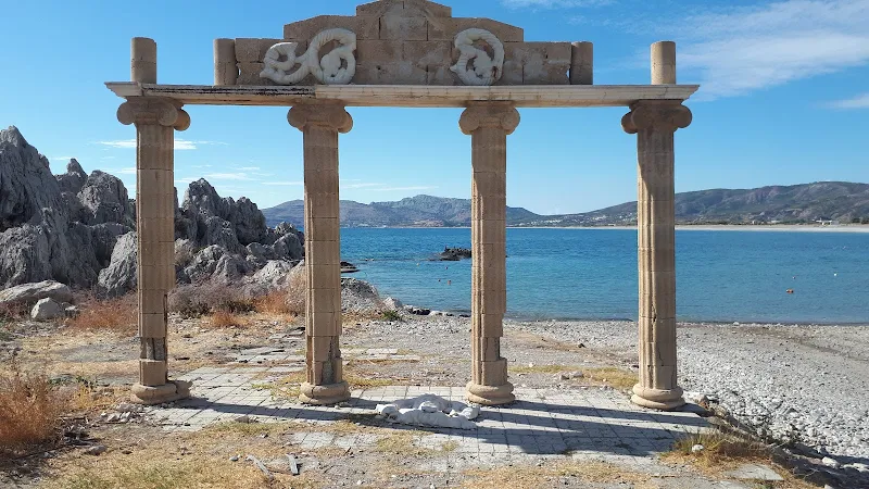
The road turns right to follow the coast and, up until 2020, one would have been confronted by a columned structure looking out to sea, an iconic sight that can be found emblazoned across numerous brochures and websites that laud their praises on Haraki. Even well respected travel media highlight this structure and refer to it as an ancient ruin. However, I can find little evidence of this being the case. The size of the columns plus their cross member was no more than 3-4m and it looked nothing more than a scaled version of typical Greek columns that adorn such magnificent ruins as the Lindos Acropolis. There has been a lot of decay over the last decade and the uprights had their stone
cladding peeling away revealing what can only be described as modern building materials, certainly nothing ancient unless the ancient Greeks were the founders of the modern breeze block. The sculpted mural that once embraced the cross member had lie discarded on the the ground. It certainly looked completely uncared for.
Although I can find no information about this anomalous landmark, my suspicion is that it was nothing more than an ornamented plaza for a hotel or guest-house or even a restaurant. I could be wrong and would be happy to be corrected if this was not the case. A visit in 2020 revealed the structure had completely gone to be replaced by a resurfaced area, complete with saplings planted in dedicated square cavities, benches added and a litter bin. I think this must conclude that there was nothing ancient about this ruin.

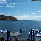
The path now leads onto the main sea front of Haraki, a beautiful enclosed bay with a sloping shingle beach surrounded by a host of tavernas and restaurants. It is quiet and peaceful at this time of the year and it is difficult to walk past the enticement of the taverna seats, eventually conceding to the impulse to take in a frappé and to spend some leisurely time gazing at this idyllic scene.
With few folk around, the focus soon came to two bottoms. Yes bottoms. Bums if your so wish. More colloquially known as arses. Now, I am no dirty minded individual but one could not help but notice and ponder an inquisitive thought at this scene of human derriers firmly pointed to the sky. There were two of them, both facing the heavens in synchronized formation, torso and legs planted firmly on the shingle and posteriors mooning upwards. Most folk sunbath laying down but these two individuals appeared to be redefining the art of a sun worshipper. Most intriguing. Even more beguiling was the fact that we were seated under the veranda of a Taverna that went by the name of Bottoms Up
and here we were sitting watching Bottoms facing Up. How uncanny was that? Was this an advertising stunt or mere coincidence. Had we been drawn to this taverna by some subconscious urge influenced by the casual glance of two skyward facing bottoms. We waited and watched. The bottoms started to contort and the bodies started to perform other ritual and mystic moves where bottoms were not involved. It soon dawned upon us that these were nothing more than two spiritual beings performing some kind of transcendent yogic exercises and our placement at said Taverna was mere coincidence.

At the far end of the beach are the ruins of Feraklos castle lording over the village. It is inviting to follow the track up to the ruins but this particular walk was about the search for a cave chapel and the visit to the castle is covered in the walk Haraki and Feraklos Castle. So after some photos, and an admiring view, we proceeded off to find our way through to Agathi Beach.
There is a path through the scrub at the back of Haraki that leads out onto the road to Agathi Beach, emerging as it turns to pass the path up to the castle ruins. This path is fairly easy to find and easy enough to follow, the grass and herbs trampled by a thousand other feet embarking upon the same short journey. Just head towards to road.
The road soon starts to head down towards the beach with some awesome coastal scenery to admire along the way. One can appreciate why someone has gone to the effort to start constructing apartments looking out over this amazing scene. There is a terrace of partially built concrete structures above the road and more just below. I have since been told that many islanders use their savings to fund the building of such apartments as an investment for the future and once completed they will be rented out as holiday accommodation for tourists. It takes a lot of time to complete the build and this accounts for the many half built structures one encounters in prime coastal areas. Each stage of the build can only proceed once the investor has the funds saved and can pay for the next construction phase, consequently it can take many years to complete a project with lengthy periods where nothing happens.
This particular enterprise, so we were enlightened by a local man in Masari, has a more intriguing story attached to it and accounts for the dilapidated state of the constructions. The whole complex of buildings was said to have been funded by a local fishermen who had grand designs on creating a small resort in this prime location. Something which would provide a better income than his meagre fishing business. To pay for this he boosted his income by taking tourists out on cruises in his fishing boat. Unfortunately one cruise ended in a tragic accident and the fishermen was the subject of many legal proceedings against him. He fled the area and has never been heard of since and the construction has come to a permanent halt, the partially completed shells becoming nothing more than a scar on the landscape. Now, I cannot verify how true this story is, and can find no reports or documentation to establish the fact but it would certainly provide an answer as to why this building enterprise looks as if it is turning to ruin.
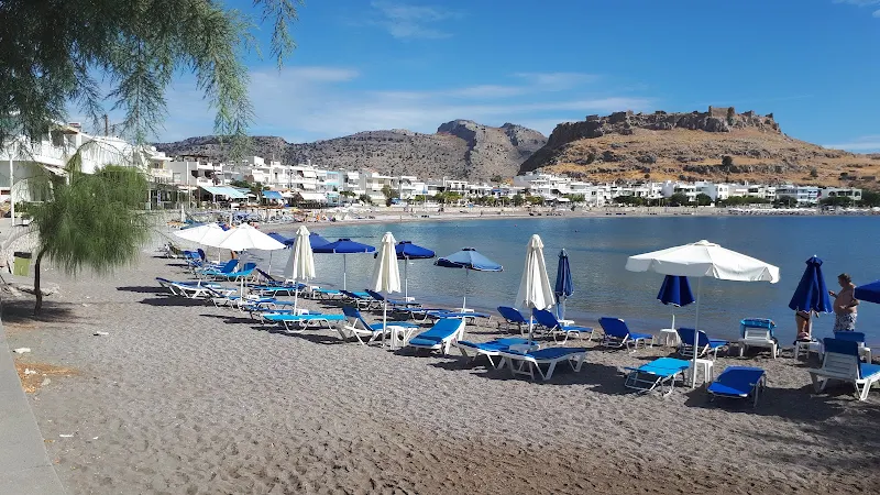
We now drop down to the beach known as Agathi. This broad glorious sandy beach has multiple kantinas and a mass of formation sunbeds and parasols. This brings in many tourists and sun seekers and probably many do not know of the chapel that exists here or the pits that were once used to store grain in days gone by. The pits are another piece of local information that is not readily available in tourist media and are said to be on the southern side of the beach. The chapel is at the north end of the beach, on a rocky ledge a metre or so above the beach, its view shielded by trees. Clamber up here or follow the track from the back end of the beach and one is drawn immediately to what looks like a bare structure, part brick that is nestled into the rock of the cliff. Inside it looks like a former squatters shelter with evidence of habitation by folk who have no particular care for the place. Graffiti is liberally daubed across the walls, there are broken stone floors and dumped items of furniture.
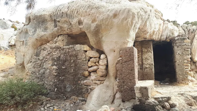
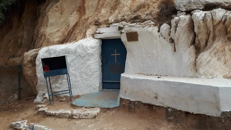
But this is not the chapel. This is some other building, probably a lot more modern. The chapel sits within the cliff itself, its entrance is an unassuming blue metal door that is decorated with a humble cross with whitewashed walls either side. To the side is a blue cast iron bell that hangs from a dedicated stand. This is the ancient cave chapel and is dedicated to St Agatha, from where, we would assume, the beach takes its name.
Inside this chapel is a revelation, adorned with icons of the saints, lighted candles and even flowers like all Greek chapels. It is obviously well used and respected. Look closer and there is even more tantalizing pieces of history for there on the walls, faded and not immediately noticed, are a myriad of wall paintings, depictions of saints. This certainly has a medieval feeling about it. And there is also graffiti, centuries of it, graffiti on top of graffiti. An obvious recent scrawl shouts out angel (ΑΓΓΕΛΟΣ)
, another John (ΓΙΑΝΝΗΣ)
, both daubed over other words etched and carved into the very rock.
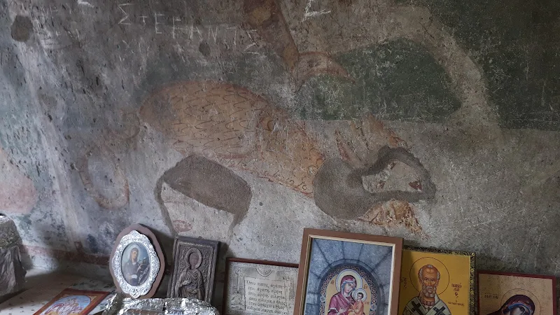
The chapel is obviously very old. A plaque on the wall besides the door declares that it is 14th/15th century which is acclaimed by the Greek Ministry of Culture. A comment accompanying a photo on flickr claims it dates from the 12th century and was used by hermits but this claim provides no citation as to where this information was obtained. Unfortunately I can find no historic information on this chapel although it is documented that numerous caves throughout Greece have religious significance and many were used for worship before the coming of Christianity. Maybe this one was connected to the additional ancient artefacts that have been found in this area, after all we had been told about tombs that existed above the chapel. In reality these are not what could be described as tombs but are more likely to be cist graves that were used for single burials during the Mycenaean period. They sit alongside the path that leads up the cliff-side. Several oblong chambers hewn out of the rock that can easily be missed when taking this path. If these are ancient archaeological finds, possibly Mycenaean, then it would explain the reason for the fence that is placed across the path and in front of the low cave adjacent to the chapel. Fortunately a section of the fence has been broken down where it meets the cliff and allows access. This has probably been forced down by walkers who have trudged the cliff path from Archangelos and then find the access to the beach barred, as we did some year previous and as we found, this necessitates a lengthy diversion.
The cave adjacent to the chapel appears to be a natural hole at the base of the cliff that tunnels into the depths. As this is also fenced off one can only assume this must have some archaeological significance. Above this cave is a double headed eagle symbol carved into the rock face, the symbol of Eastern Christian Orthodoxy that was the official state symbol of the late Byzantine Empire which symbolized the union of church and state. Once again I can find no documentation, no archaeological reports, not even a brief mention of discovery about these caves or graves.
So we leave this place with so many questions? How old is the chapel, was it a site of religious worship before the 14th century as some insinuate? Was it even older, maybe a site of religious worship prior to Christianity? Is there a connection between the graves and the chapel?
This is certainly a revelation by any means and makes a worthy reward for the search.
Directions
The route follows tracks to Haraki and then follows the coast to Agathi Beach before returning to the main road. There are bus stops at either end.
The walk starts at the Masari/Haraki crossroads on the main Route 95 Eastern highway. Note that this is not the main road into Haraki which junctions with the Malona crossroads. To the left of the Haraki road is a hard surfaced track. Take this, ignoring all turns. It passes a building on the left, then makes a sharp left turn. After another 300m there is a junction, bear around to the right. After another 180m the track turns to the right and passes a largish chapel complex. Continue onwards ignoring all other side routes for 300m where the track bears right and then soon junctions with another track. Turn left and continue for 550m where there is a track on the right. Take this and continue down to the road (400m). Turn left and follow the road to the coast. This makes a sharp turn and follows the beach, across the river bed and into Haraki. Turn right and keep following the coast and the road leads onto the sea front of Haraki, lined with tavernas and restaurants.
Continue around the bay to the far end and take the road that turns back on itself and up a hill. Above is the castle. Continue following this road around the back of the village until there is some waste ground on the right. At the far end, this leads onto a path across the scrub. Although there is plenty of grass and herbs, there is a defined route made by many feet that leads across to the road that leads down to Agathi Beach. Follow the road to the beach and where it meets the beach entrance may a point to remember this location. Cross the beach to the far end where the Chapel cave sits in the rock face.
To continue from here one needs to climb to the top of the cliff via the footpath that leads off the other side of the fence that guards the chapel area. This did prevent access but the end of the fence where it meets the cliff face has been broken down to allow one to step through and onto the footpath which leads on a hair pin bend up to the top. If this option is prevented by any future reinstating of the fence, return to the point where the road met the beach. Turn right and continue along the track that leads away from the beach and will join the track described below.
At the top of the cliff head straight ahead along the track. Do not turn right. Continue along this track ignoring all other side tracks. After 1.3km it meets the main road into Haraki. Turn right and continue to the crossroads where there are bus stops on either side of the road.
Refreshments
Bottoms Up, Haraki View in Google Map
- Address
- Bottoms Up, Haraki
- Website
- https://www.facebook.com/people/Bottoms-up-kitchen-cafe-haraki/100054478270387/
Beach side cafe on Haraki sea front
There are plenty of places to sit and take a drink around Haraki sea front. This was selected at random and was a perfect place to sit and watch life roll by with as much immediacy as the gentle lapping tide against the shingle.
Image Gallery


Route Validation Cards
Validation Date - 2019-10-07
- Time of Walk: 10:00 to 13:00
- Validators: Griffmonster, Kat
- Weather Conditions: Warm sunny day with clear blue skies
- Notes: Initial route undertaken
Summary of Document Changes
Last Updated: 2026-03-30
- 2019-10-16 : Additional information about the broken down fence that used to bar access to Agathi beach and adjustment of map route to provide the best route through
- 2020-10-21 : Update on the Haraki Columns which had been removed by 2020
- 2020-11-29 : Provide link to Haraki Castle walk
- 2021-03-17 : Update website improvements and removal of ViewRanger reliance
- 2021-12-01 : Removal of ViewRanger links due to its imminent demise
- 2026-01-12 : Major website update with all walks recast to the new format


1 comments:
I loved your article and have done this awesome walk myself. I often wondered about the derelict buildings near Agathi beach and now my questions have been probably accurately answered. I did too ask a local about this and was told the person had gone bankrupt or something. Finding the very old chapel was the highlight of one of many happy days spent in Charaki. Returning soon after 8 years - can't wait.
Post a Comment