Walk to Masari Mountain Chapel
A walk to the chapel on the summit of the mountain to the immediate north east of Masari
This is not a clamber up the sides of a scrub and rocky mountain, but follows a track that curves around the mountain which looms behind Masari village. At the summit is a small chapel where a deserved rest can be taken before returning along the same route. Do not be taken in that this is easy. With little in the way of shade, this is a tough climb in the heat. Take plenty of water and do not attempt in the heat of summer.

Walk Statistics
- Start location: Masari
- End location: Mountain
- Distance: km ( miles)
- Total Gain: metre ( ft)
- Total Descent: metre ( ft)
- Min Height: metre ( ft)
- Max Height: metre ( ft)
- Est. Walk Time:
- Walk type: Linear
- Walk Grade: Difficult. Although the tracks are easy under foot and paved for most of the assent, there is little shade which makes a demanding assent in the heat of the sun
- Terrain: Dirt/paved tracks
- Obstacles: It should be emphasized that this is a demanding walk. You should be fit and take plenty of water

Maps
The following maps and services can assist in navigating this route. There are links to printed maps and links to downloadable GPX route data for importing into navigational software and apps.
- GPX Route File
Accommodation
Pefkos Blue Studios, PefkosapartmentView in Google Map
- Website
- https://www.pefkosbluehotel.com/
- Description
- Pefkos Blue formerly known as Dimitri Studios, offering self catering apartment studios overlooking Pefkos village with splendid views across the bay. This is probably the best place in Pefkos if you want to be away from the village. Above the hubbub it offers unrivalled views and a quiet location.
Transport
Rhodes Public Transport - Bus Service
- Service Details
- Gennadi to Rhodes Town - KTEL Rhodes Public bus service serving the East Coast of Rhodes linking Gennadi, Kiotari, Lardos, Pefkos, Kalathos, Archangelos, Afandou, Faliraki and Rhodes Town
- Timetable
- https://www.ktelrodou.gr/
Walk Notes
To the north east of Masari is a 324m (1062ft) high mountain. The Orama hiking map marks the area as Πλάτσα
which Latinised is Platsa. Of all the maps I have thus far studied this is the only modern map that places a name on the area. An old Italian map from 1935 marks the area with the word Plaza. However this placement is offset from summit and is marked across the lower reaches of the mountain. The extent of the mountain including the summit is marked with another word which is difficult to determine from the online image, although it looks like catagreno
for which I can find no translation.
There is no specific significance attached to this mountain and although it is the tallest in the immediate locality of Masari, there are far taller and challenging mountains within easy reach. It has no reference in tourist literature. No mention in books. The lack of a clear name also adds to its anonymity. The only reason it was brought to my attention was through perusing Google Earth satellite images in search of places to explore. Zooming on this area revealed some kind of structure at the summit. A definite construction perched on the edge of the northern face overlooking a cliff. The first thought was that it must be a chapel or monastery or religious building as many such places are placed at the summit of hills and mountains. The question was put to our Greek friends from Masari and sure enough they affirmed that, yes this was a chapel. We could not determine its dedication but it was nonetheless a goal, and an aim for a walk.
A map was plotted, as linked here, on ViewRanger, which was a linear route. There and back along the same route. Therefore the total distance is double that recorded on the map. The track of the actual walked route was 6.94 miles. This used dirt tracks out of Masari and the then returned via the road which although was once the National road is now no more a back road linking the villages of Malona and Masari.
This route uses the track that leads around the mountain which is hard surfaced for much of the distance. Some hiking purists may object to this trail as being described as a mountain climb as anyone can walk up a road. But that is not the point. True, it is easy going under foot, but never think that this is going to be a walk in the park. This is quite an assent and even in the Rhodes heat of a mid October morning it becomes a demanding task that should not be attempted by anyone other than experienced and fit walkers. Take plenty of water as there is virtually no shade. When I state plenty of water, I mean plenty. We took a litre each and this was not really enough, having to assess whether to continue half way up. Certainly do not attempt this walk in the heat of summer.

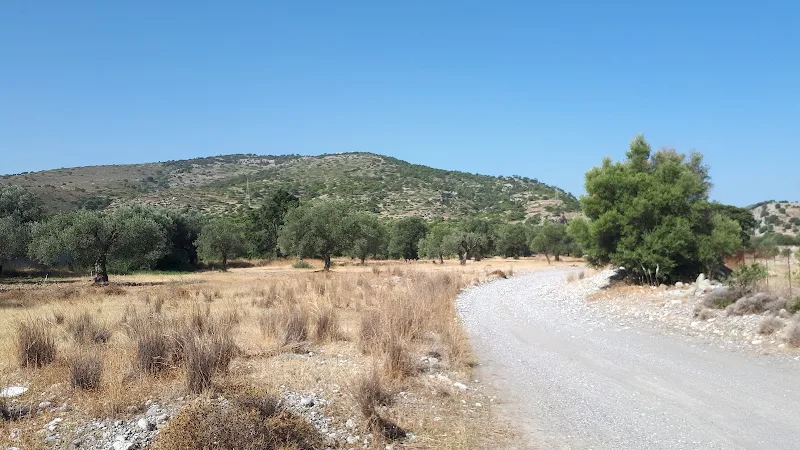
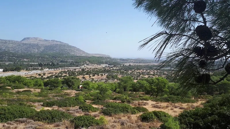
To start the expedition we headed out through the olive groves to the west of the village of Masari. This is easy walking over dirt tracks although, as is the usual case when heading through the Rhodes countryside, there are many intersecting paths and tracks which may be confusing when navigating. In this instance, the GPS certainly clarified the tracks to take. Alternatively there is always the main road through to Malona which these dirt tracks meet up with at the point where the main mountain track begins.
Initially the dirt track to the mountain follows alongside the course of the dry river bed before turning away to head to a copse of trees where a little chapel nestles under the shade they provide. This is the chapel dedicated to Ευαγγελίστρια
, the Evangelist. This became our base-camp as it was a place to rest and relax in the cool shade of the fruit trees that surround the small quadrangle in front of the chapel. On this initial visit it gave us the chance to look inside and admire the icons and paintings that adorn he walls and ceiling of this humble place. A lizard sat on the door frame. I looked at the lizard. The lizard did not even pretend to look back at me. It just knew I was there like lizards always know such things and before I could grab my camera it was chasing off to who knows where. All I captured was a blurred image of a lizard tail disappearing in lizard like fashion.
The chapel marks the start of the assent and it cannot be stressed strongly enough that there is no more shade until the summit. From this point until the summit one will be under the blazing sun. That doesn't sound too much of a task, but given the assent it will takes its toll. Take heed.
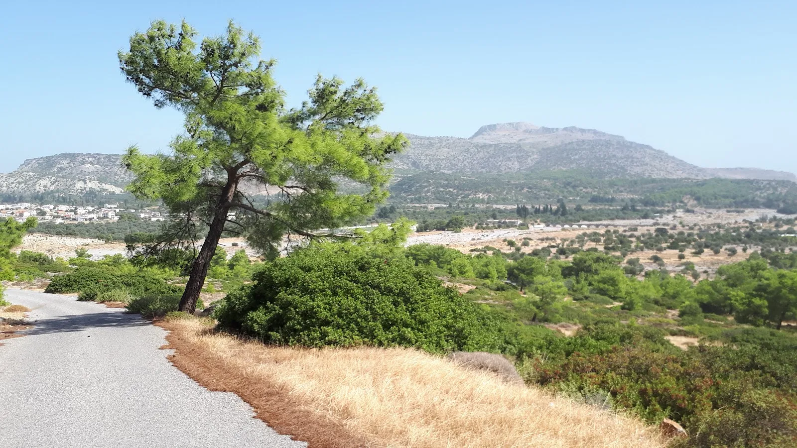
The track curves around a double bend to become a surfaced road which makes the going easier underfoot. The way ahead varies between steep climbs and slow inclines. It looks easy but in the heat it soon becomes a labour. We soon reach 150m. Without a doubt the views are amazing from here with a panorama from Kalathos beach through to Haraki with the backdrop of mountains that exclude the view from further along the coast. Admiring such views is part of the climb, an excuse to stop, to take a breather, to take a swig of water. The official temperature was high 20's°C but under the baking sun it felt so much more. At this height, half way up the assent, the question was seriously debated on whether it was wise to carry on. Hearts pounding. Sweat dripping from foreheads despite sun shielding hats. Water diminishing. It has to be said, we are both regular walkers, thinking nothing of undertaking 20+ mile hikes over various terrains of our native England. It was neither that we were not acclimatised to the Rhodes heat as this was the end walk to a 10 day itinerary. After some discussion the decision was made to continue to where the road curved around to the far side of the mountain and then re-assess the situation.
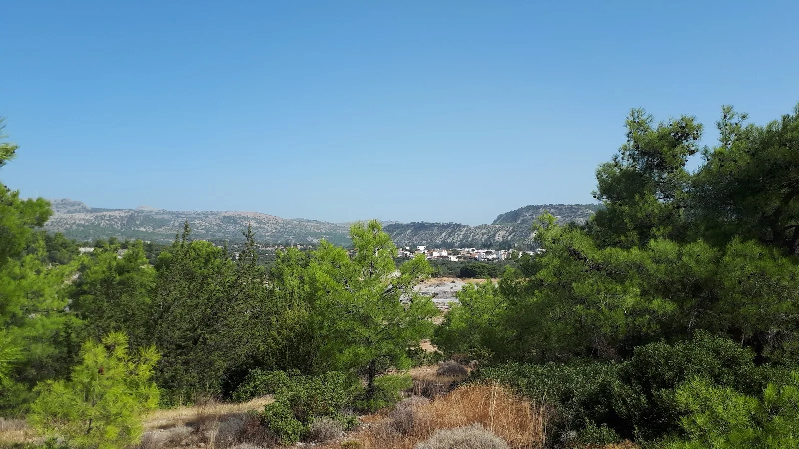
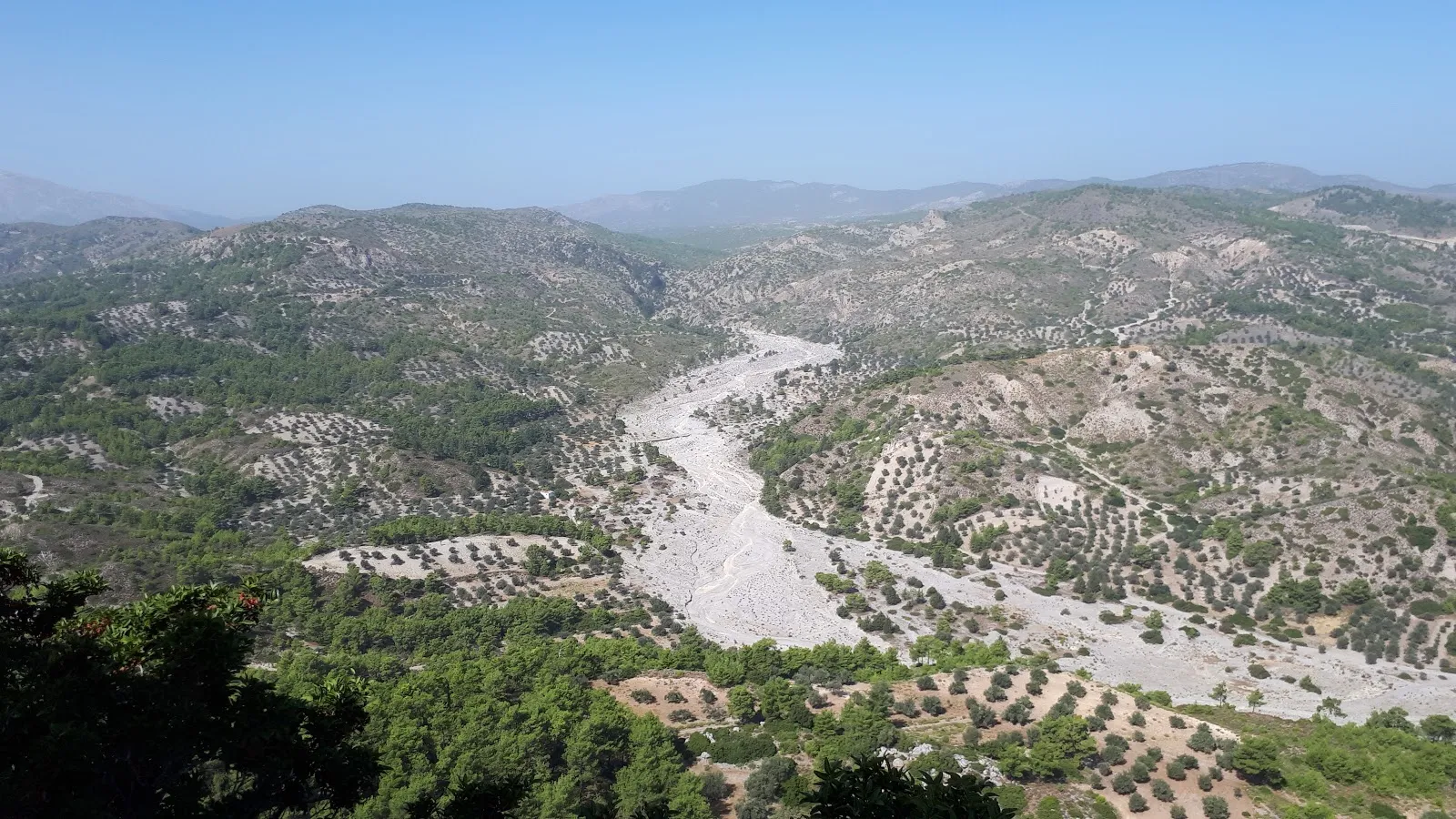
Another steep climb. The pace was kept down as we quickly gained more height. A glimpse of the chapel on the summit gave encouragement that maybe this could be achieved. The track curved around to head north west. The views changed revealing the valley where the Skoutoularis river cuts between the hills in a deep gorge. We were now at 200m. Two thread-bare trees offered scant shade, although this was better than nothing. On the mountainside opposite we could pick out the Kamiri monastery nestled in the pine tree shaded hills. Glorious views. The question as to whether to continue was once again debated. Half the water had been drank. Legs were fine, it was the blistering heat that was the issue. In the end, the fact that we had now covered some 2/3rd of the height gave a push to continue. The road curved around to the far side of the mountain and we could not see the immediate route ahead but the map indicated that there was not much more distance. Take it slow. One step at a time. Maybe there would be additional water available at the top. Nonetheless the water had to be rationed with enough for the return journey.
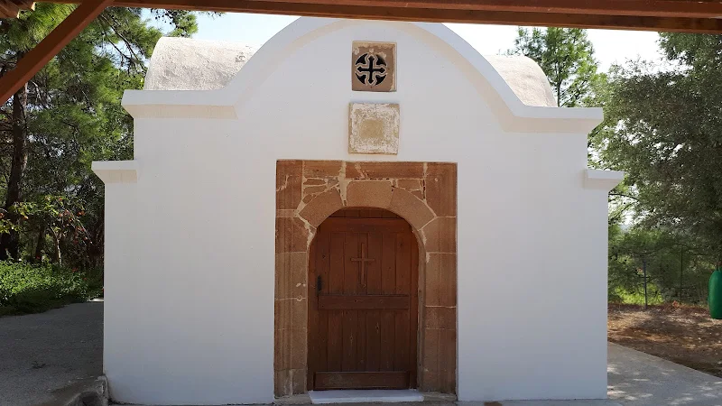
The final 100m climb was tortuous in the heat with a tough gradient that led to the gates of the chapel compound. Slowly heading upwards and onwards. Frequent stops every few yards. Admire the views then a few more steps. Then slowly but surely the entrance came into view and that rush of relief passed through the body as we entered the complex at the top, a sense of achievement that the main mission was successfully accomplished. The pains and thirst briefly forgotten about when a fantastic 360° panorama presented itself.
The summit consisted of a small chapel with no written dedication on its stones, with an adjacent covered shelter which provided relieving shade and where a few plastic chairs gave the chance to sit and rest and to capture ones breath, to take a swig of water and for a few minutes, bathe in the glory of getting to the top. There was no additional water available, unless the large blue plastic storage containers held water and that is something we did not want to put to the test.
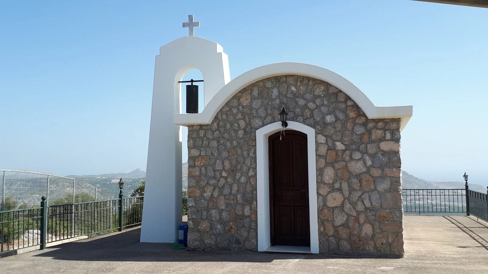
The chapel was a simple building of stone, obviously recently constructed as evidenced by the clean stonework. The interior was typical of Greek chapels on Rhodes adorned with brightly coloured icons of the saints. Connected to the chapels north wall was a simple arch holding a long and unusual cylindrical bell from which a rope dangled. A ringing of the bell had to be done to give thanks that we had safely accomplished the pilgrimage. The chime resounded across the valleys below announcing to all and sundry that we had arrived.
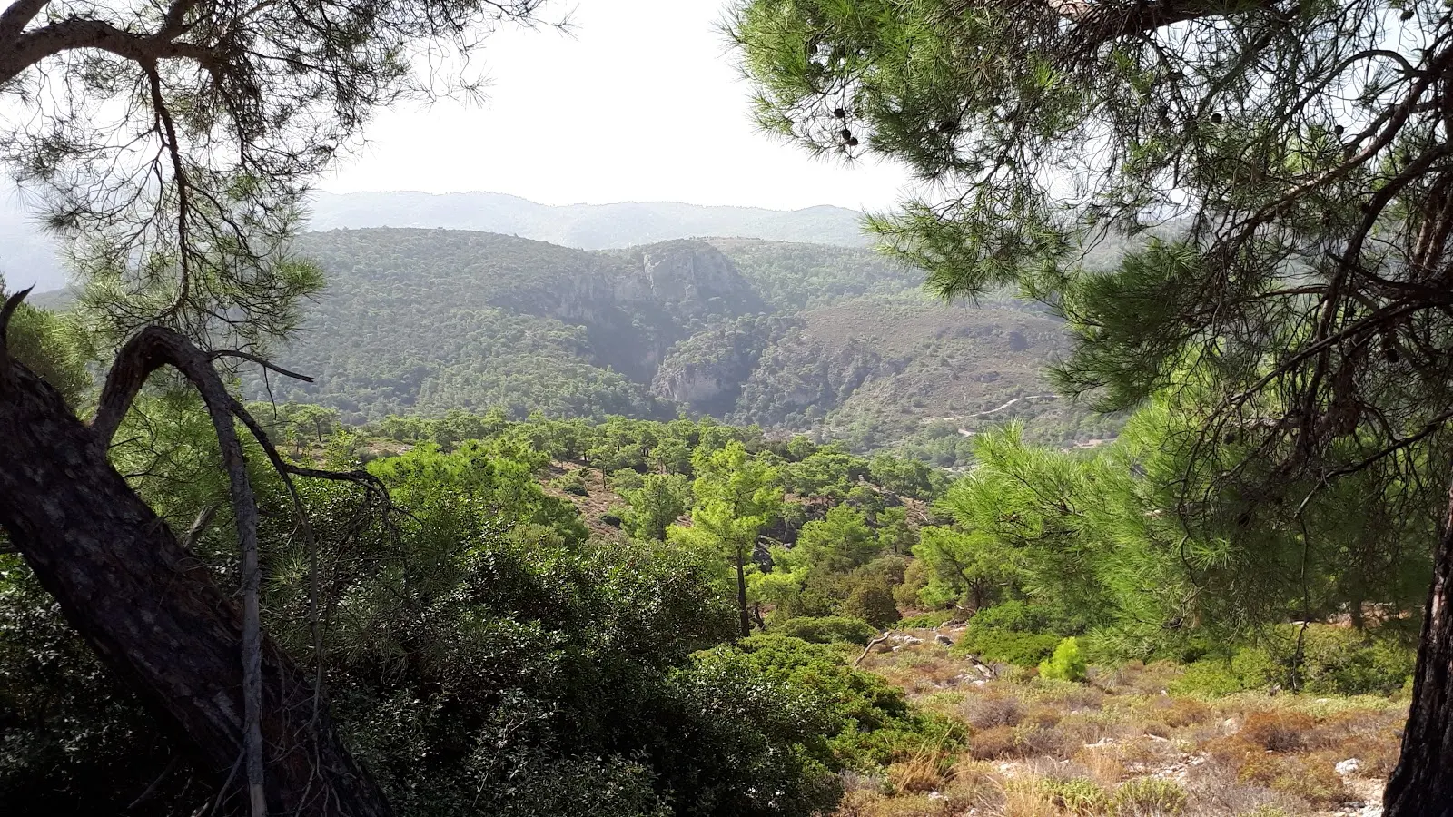
What a location. What views. One can understand why chapels are placed in such locations, to honour the glory of the divine that manifests itself in the over-awing view of creation itself; the coast, the deep blue sea, the mountains, the stony valleys where winter waters would eventually cascade and the whole blue firmament that this creation sits under. It is a true wonder. To witness this made the whole effort of climbing this mountain a worthwhile feat.
To the west, below the sudden drop of the cliff that the chapel was perched upon, was the river bed that meandered up into the hills, its wide course narrowing as it led inland. A tiny chapel could be glimpsed just off of the river valley. An inspiration for a future exploration.

It may sound like the bleeding obvious but the return journey was a whole lot easier. This is not such a silly remark to make, personally I prefer assent to descent as going down puts a lot of strain on the ankles in a somewhat unnatural way. Having said this, the paved surface does provided a distinct advantage in descending, making it much easier than a rough surface with the going a much more speedier than the assent.
A dirt track leading away from the main track was noticed which certainly stirred the curiosity as to whether this provided an alternative route down to Masari. However, with limited water supplies left it would have been folly to follow this. Later research revealed it may have provided a circular route to this walk but it is uncertain if access to the foot of the mountain can be achieved without a rough scramble or climb down the lower reaches. It would be interesting to hear if anyone else had investigated this route.
The base camp chapel was reached in a fraction of the time it had taken to accomplish the climb and its trees provided much needed shelter and respite from the sun. A hose pipe that straddled unceremoniously across the courtyard held the promise of cooling water to splash across ones face. I turned the tap that it was connected to and aimed the hose at my head. The exuded water was more than hot, almost scolding, resulting in flinching away and turning off the supply. The hot sun had baked this pipe throughout the morning and it was far from refreshing. With no more than a dribble of water left in the bottles, this had to suffice until we got back into town.
At the bottom of the mountain track we headed back into Masari via the main road where another chapel was encountered on the roadside. More shade and another hosepipe. This had sat in shade, and despite being warm was certainly not scolding like the previous hosepipe. A rejoicing dousing of water was liberally applied over the head which sufficed until we got into town where cans of ice cold lemonade was purchased from the first mini-market shop. This was swiftly consumed in the shade on the opposite side of the road amidst the lively school kids who were grouped around this area, their schooling done for the day.
At the centre of the village, adjacent to the Ιερός Ναός
, Holy Temple, with its multi tiered bell tower that looms above the village, is the Rendez-vous bar, a taverna whose street tables sit under the cool shade of thick broad leaved trees. A great place to pass the time and watch the world go by with a beer and food to celebrate the conclusion to the days adventures.
The bus stop is next to the taverna and, certainly for going back to Lindos and Pefkos, makes an easy place to embark. Failing this one can always wander down to the main road to catch the buses that do not run through the village.
To conclude, this walk was worth its while but do not underestimate its challenge. It is very demanding purely with respect to the heat. It may not be for the purist mountain climber, but this is not what this website is about, which is aimed at exploring this fascinating island, of going off the normal tourist destinations. It is true that one could drive to the summit and we did indeed pass a car heading up as we walked back, but that is never a challenge. Driving does not envelop one into the whole scenery, it does not provide the accomplishment of a pilgrimage on foot. Walking will provide the attainment of glory, driving will just give you another tick on the list of places visited.
Directions
Straight forward assent of the mountain behind Masari along the purpose built track to the summit
From the main square in the centre of Masari, proceed up the main thoroughfare through the village heading towards Malona. After some 170m, take a left turn into a back street, this is opposite a grubby old looking domestic building. Continue along this, ignoring the first turn on the right. After 250 m take the dirt track on the right. Keep to this, taking the left fork a little further on. Keep to this track. At the cross junction go straight ahead, this may not look obvious at first. The next junction turn right and follow this broad dirt track until it meets back up with the main road. NOTE - alternatively follow the main road out of Masari.
Take the dirt track that leads away from the main road. This follows the course of a river bed. After 400m the track turns sharp left with another track leading straight on. Take the left and follow this past a chapel and then around a double bend where the track becomes surfaced. Follow this track to the summit.
Return is the same as the outward journey
Refreshments
Rendez-vous Bar, Masari View in Google Map
- Address
- The Square, Masari
Taverna in the centre of Masari with street seating under broad trees that form a welcome respite from the heat of the day. A grat place to sit and watch the world go by.
After the hike through the heat of the day this little bar offered the perfect conclusion to the walk under the leafy cool surrounds. Friendly little taverna used by the locals. The bus stop is adjacent to the taverna.
Image Gallery
Route Validation Cards
Validation Date - 2019-10-12
- Time of Walk: 10:30 to 13:30
- Validators: Griffmonster, Kat
- Weather Conditions: Very warm day
- Notes: Initial route undertaken
Summary of Document Changes
Last Updated: 2026-03-30
- 2021-03-17 : Update website improvements and removal of ViewRanger reliance
- 2021-12-01 : Removal of ViewRanger links due to its imminent demise
- 2026-01-12 : Major website update with all walks recast to the new format


0 comments:
Post a Comment