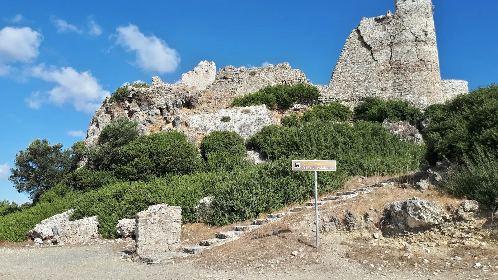
Trek to Asklipio Castle

A 9 mile circular walk from Kiotari to Asklipio
This walk follows a route up the river valley and then up into Asklipio and onto its castle ruins. This is a great day out and well worth the effort. Asklipio is a traditional Greek village, nestled in the hills and far from the maddening crowds.

Walk Statistics
- Start location: Kiotari
- Distance: km ( miles)
- Total Gain: metre ( ft)
- Total Descent: metre ( ft)
- Min Height: metre ( ft)
- Max Height: metre ( ft)
- Est. Walk Time:
- Walk type: Circular
- Walk Grade: Fairly easy. The tracks are never too rough.
- Terrain: Dirt tracks
- Obstacles: The castle does have some very rough ground. Use a bit of common sense when wandering around this

Maps
The following maps and services can assist in navigating this route. There are links to printed maps and links to downloadable GPX route data for importing into navigational software and apps.
- GPX Route File
Accommodation
Pefkos Blue Studios, PefkosapartmentView in Google Map
- Website
- https://www.pefkosbluehotel.com/
- Description
- Pefkos Blue formerly known as Dimitri Studios, offering self catering apartment studios overlooking Pefkos village with splendid views across the bay. This is probably the best place in Pefkos if you want to be away from the village. Above the hubbub it offers unrivalled views and a quiet location.
Transport
Rhodes Public Transport - Bus Service
- Service Details
- Gennadi to Rhodes Town - KTEL Rhodes Public bus service serving the East Coast of Rhodes linking Gennadi, Kiotari, Lardos, Pefkos, Kalathos, Archangelos, Afandou, Faliraki and Rhodes Town
- Timetable
- https://www.ktelrodou.gr/
Walk Notes
It has to be said that this walk is very similar to the Easy Walk from Kiotari to Asklipio that also appears on this site. I make no apology, that walk can be undertaken by just about anyone following the basic instructions and relies upon the road to return and at only 5.5 miles is nearly half the distance of this more adventurous walk. This walk uses the river valley from where tracks lead up to Asklipio. To try to find this in the opposite direction without GPS navigation would be down to either very good local knowledge or plain luck due to the maze of alleys and streets that lie between the centre of Asklipio and the track down the hill.
As is the case on most of the walks on this site, we were based in Pefkos and used public transport to get to the start if this walk. Southbound buses either terminate at Kiotari or travel onwards to Gennadi. What ever bus one catches the stop needed is the southern end of Kiotari, at the roundabout with the Asklipio road. Kiotari bound buses will, as in this case, use the roundabout to turn back on themselves ready for a return journey.
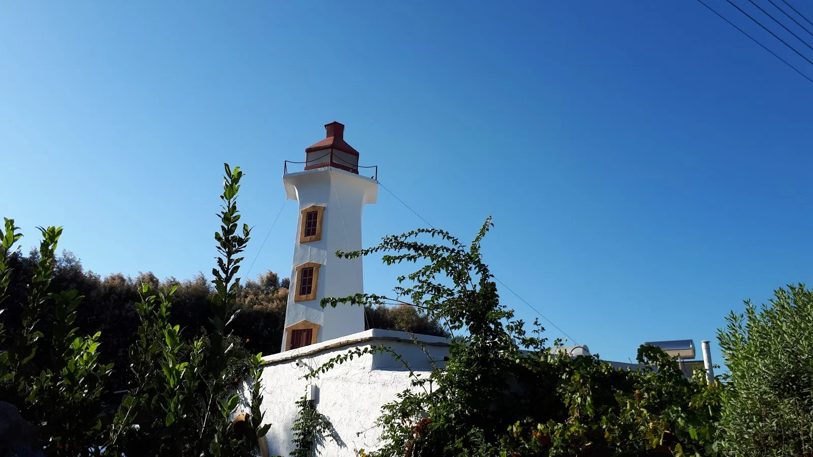
From the bus stop there is a 1.6km walk southwards to get to the river valley. The best method to get there is to come away from the main highway by heading down the beach road and then taking the coast road which has very little traffic and makes for a very pleasant and easy stroll. This side of Kiotari has plenty of tavernas, restaurants and apartments but certainly could not be considered built up with much countryside interspersed between the developments. On the coast side, an iconic restaurant is the Lighthouse where a hexagonal column with windows stacked one above another rises above the other villas set around the beach. This clearly looks like a lighthouse with a light room at the pinnacle and a walkway around it. There is no indication of whether this lighthouse was a modern artefact constructed by the restaurant or was indeed an old lighthouse that set the theme to the restaurant which first opened in 1992. This coastal section of Southern Rhodes was defended by a series of lookout towers back in the 15th century so could this have been a reconstructed tower? By the look of the structure it does look far too modern. But who knows.
The road crosses a dry river bed. I would assume a bridge once spanned this but these days the road drops down to negotiate a route across the river bed. Looking inland there is the sturdy bridge that carries the main road, probably the reason why if there was a bridge here it never got replaced. This is the the Asklipinos river, and no doubt it is witness to surging currents of water during winter months, taking down the rains from the hills above Asklipio. On the far side of the river is the Minas Villa apartments with a round structure in its courtyard that looks as if it could have been a windmill at one time. Once again information is not forthcoming and we can only speculate.
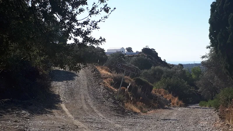
The next right turn is where the trek up the valley begins. A road leads up to the main highway from where a track leads away on the other side. This must be a fertile valley as at this low level there is farmland rather than customary olive groves. We witness an old tractor at the far end of one of the fields, a plough attached to its rear which has obviously recently been used judging by the turned earth.
A little further on is a single concrete wall that appears to have no use other than to hold back a mound of earth behind it. An odd looking structure. The track rises past this landmark, and as we walk onward the farmland soon gives way to the customary olive groves. A solar farm is placed close to the tall electric grid pylons which stretch across the valley. All the time, to the right is the river bed, wide and waterless. Eventually the track drops down right next to it and there is a track across, this being the way through to Asklipio. It is very wide here, over 200m from side to side. The course of the river is full of growth and not just herbs and newly sprung plants, one also witnesses established bushes which begs the question of how they survive the torrents that must surge down this valley after winter storms. Maybe it has just not rained much over the last few years.
On the far side the track rises quickly. The river valley is some 60m above sea level and Asklipio is 170m and this climb is accomplished in some 900m as the crow flies, assuming the common crow flies around Rhodes. I am no ornithologist so we shall assume that if these common British birds are not common on Greek islands then another species does the distance calculations.
The climb soon encounters a turn off, which doubles back and a sign announces St Georges chapel. The sign has greek characters on a top line, then translated below to Latinised form with St George Al Labra
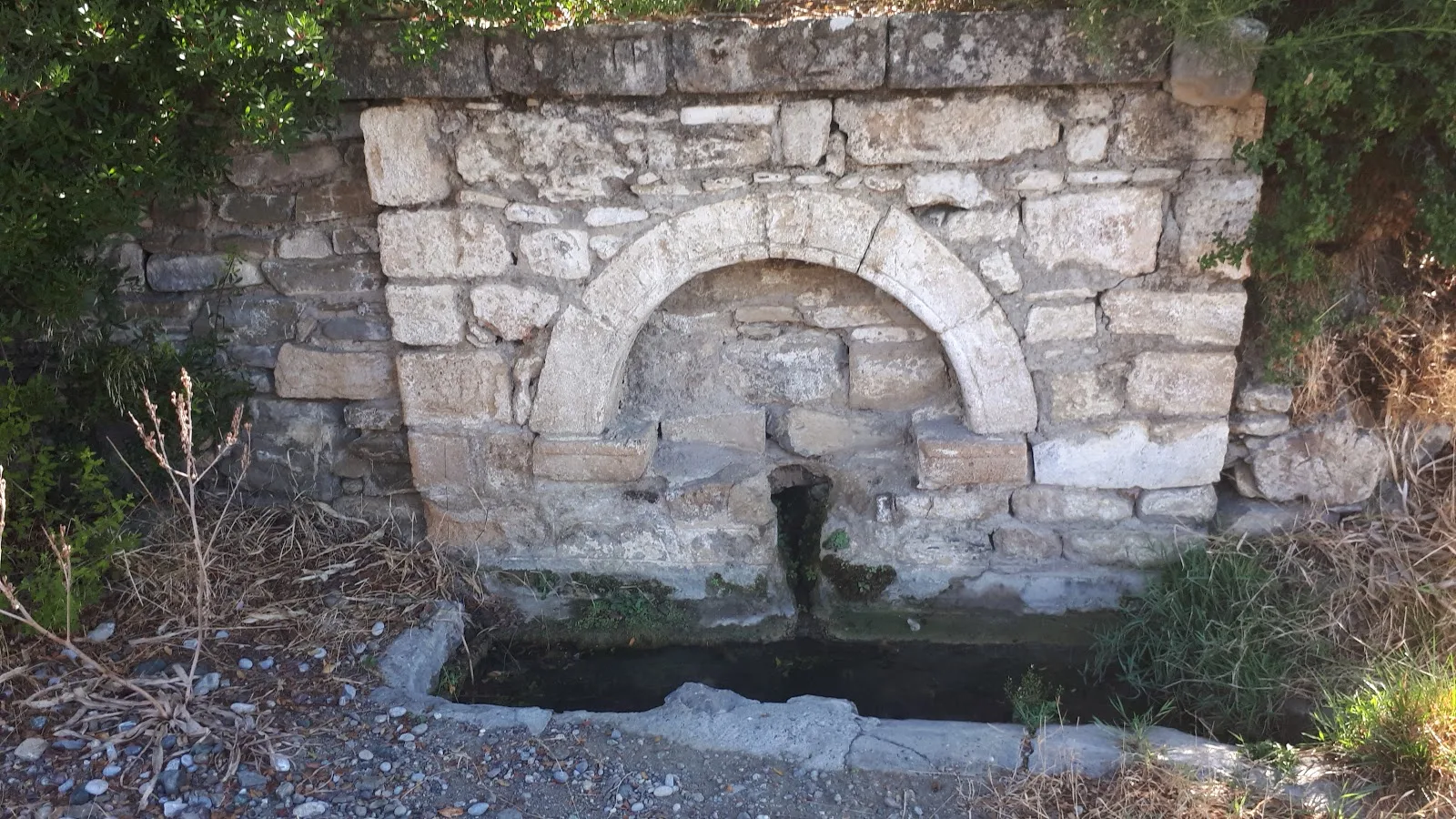
below. I am uncertain what the Al Labra indicates. Taking some wild guesses, could this be the plural of Labrum which is a lip, or a water basin with a overhanging lip, or could it be a mistranslation of Libya which is said to be where St George slayed the dragon. Who knows? The small chapel is only just over 100m from the turn. Just beyond this junction is also a little spring with an ornamental stone wall built around it.
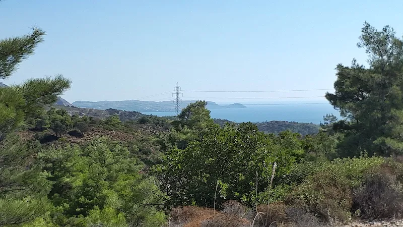
As the track climbs further, the views become more and more stunning, with a panorama up the river valley that has the mountains in the background. The tallest peak is Attavyros, and at 1212m it is highest mountain on the island. To put this into some kind of perspective for British readers, Snowden in Wales is only 1085m.
Looking upwards one catches glimpses of the village of Asklipio. A huddle of whitewashed buildings that nestle around the summit of the hill and crowned with the Castle. A wondrous sight, the whole scene at one with nature with no noise or commotion apart from the songs of nature.
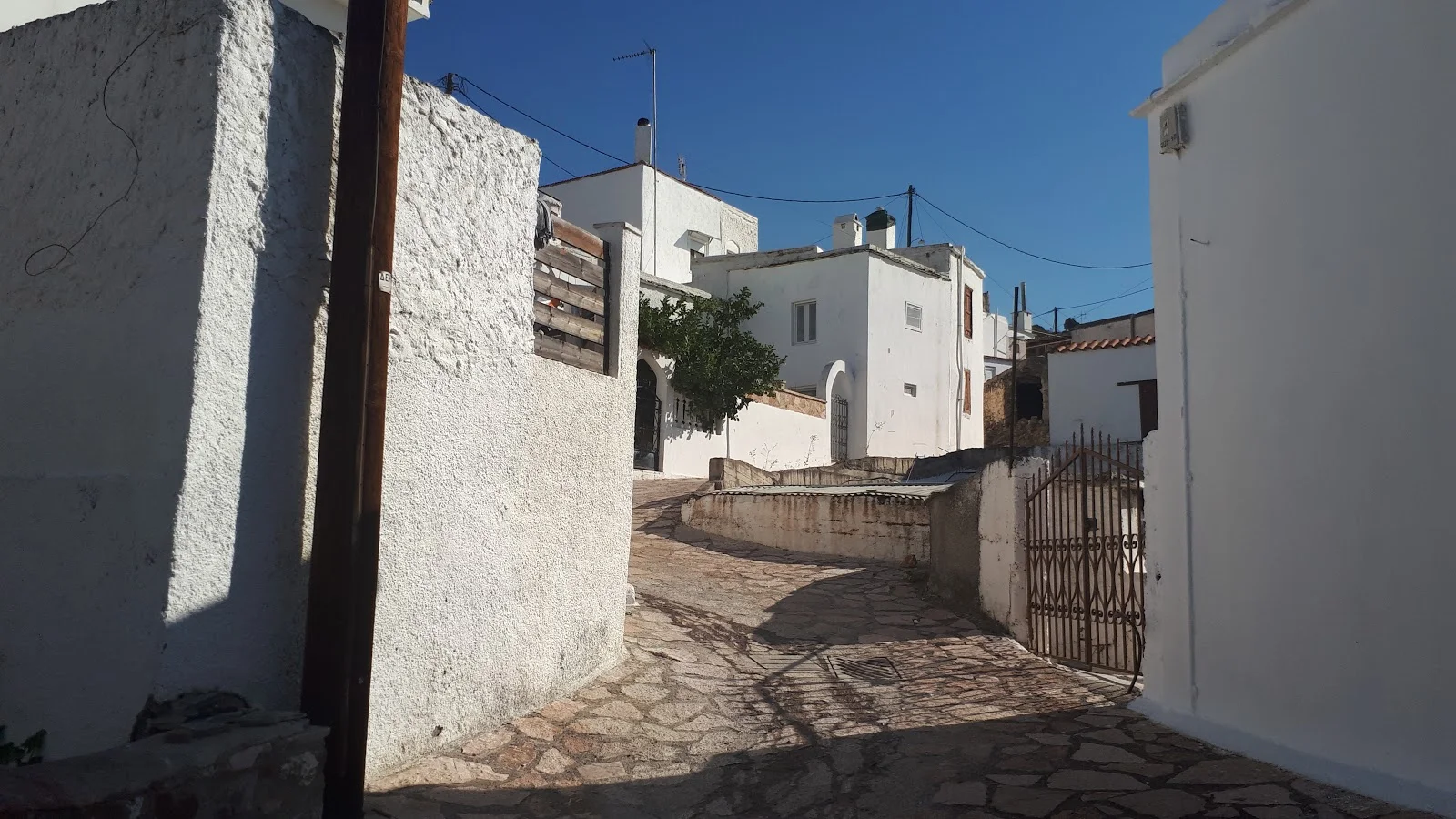
The track skirts around the western side of the village until an alley between the dwellings leads up into the heart and soul of the place. There is an intricate maze of whitewashed buildings and little alleyways, some crazy paved, some with small steps, and all twisting and turning through the buildings with no clear sense of direction. Even the few disused old buildings appear to be a integral part of this rich tapestry, all fading into the landscape. The local cat sits and gazes with all the time in the entire world in the shade of a vine that straddles the alley, another slouches on the saddle of a moped. If there was ever a place to desire to live in Rhodes, then one couldn't hope for better than this.
This mazed network of alleys is what makes it so difficult to navigate in the opposite direction. Walking into the village one merely heads towards the church bell tower which stands above everything else. There are no landmarks when walking in the opposite direction and therefore difficult to find the right track down the hill.
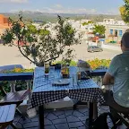
The village is centred around the church. There is a large car park in front of it, devoid of cars, and opposite is the Agapitos Taverna which sits on a shady terrace overlooking the church. This is very much a traditional Greek Taverna, and the old men of the village gather seated around the chequered table-clothed tables and proffer conversation, in tones that cascade up and down, at times seemingly heated and then laughter and choruses of approval. We offer a humble Kalimera
as we enter the veranda, they all respond in a welcoming fashion and allow us through to a spare table. The waitress speaks a little English, enough to get by and enough to exchange a few words as we order Frappes and cake. Then there is nothing better than resting and taking this all in.
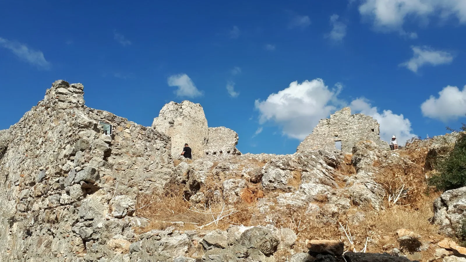
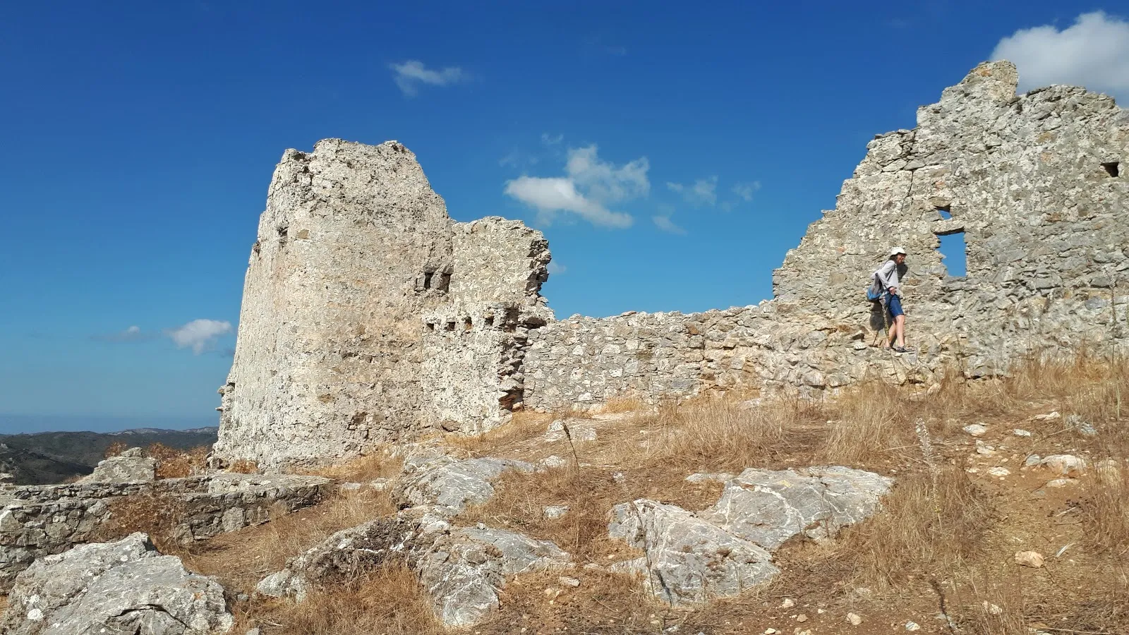
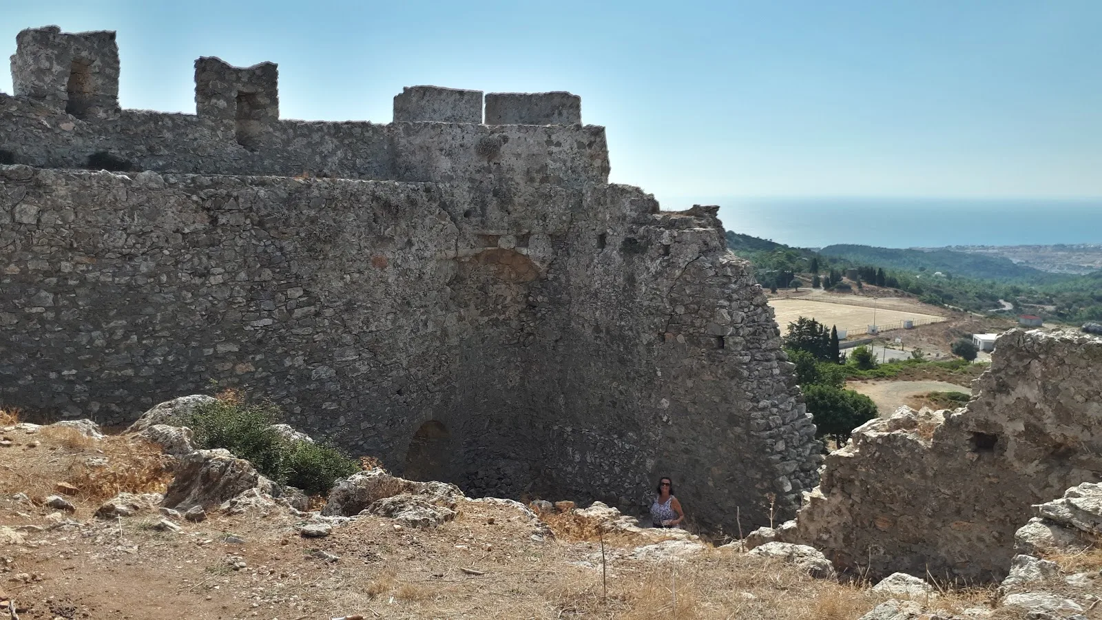
The Castle sits behind the village on the top of a hill at the end of a hair pin bend on the surfaced road. Entrance is up a flight of stone steps and through an arched doorway set in the foot of one of the turrets. The structure is in ruins but there is enough to get an indication that this was once a large structure. The tower at the entrance is pretty much intact and makes a fitting welcome. The central part is accessed by a scramble up a stony old bank onto the rough surface above. There is plenty of large stones and rubble from former buildings and floodlights are discreetly placed to shine up at the walls during the night. As with a lot of Greek places, there are no safety guards along the stone walkways that line the walls and in places there are some sheer drops. Health and safety is down to common sense. Just like the old days in Britain. The castle is an impressive sight and well worth the effort to take time out and immerse onself in the history and take in the amazing panoramic views. I have written up a short discourse on the history of the castle which is contained in the main feature on this page.
As we leave we pass a large party of French tourists whose group was seemingly being ferried up in the back of a pickup truck. This seems a popular method by Greek entrepreneurs to provide the more adventurous tourists so called safari tours of the island, by driving them off road to locations they would not otherwise be able to get to. The truck comes up from the track that leads back down to Kiotari and another set of tourists join the first waiting at the bottom of the road to the castle. Of course one can always be even more adventurous and follow the walk described upon this very page, the benefits being the solitude, the open countryside and a sense of rewarding fulfilment in achieving ones aims.
The final section is a fairly easy amble down through the countryside to Kiotari. There are outstanding views of the coast all the way along this route which makes it a sheer pleasure in walking.
At the end of the track is Kiotari, and the coast road ican be accessed on the opposite side of the road just beyond the adjacent shops. This will return one back to the start of the walk. On this occasion, however, we took the coast path up to Glystra beach, but that is another walk, another story. Whatever or wherever one wants to end up, there are plenty of bus stops through Kiotari.
Directions
Circular route from Kiotari up to Asklipio castle
The start of the walk is the junction with the road to Asklipio and the main Rhodes eastern highway. There is a bus stop by the roundabout and this is the southerly end for Kiotari terminating buses.
From the main highway head to the beach where the coast road runs alongside. Head south. Keep to this road for 0.9km. It will pass over a river bed about half way along, and then come to a turning on the right. Take this up to the main road, then cross over onto the track the other side. Keep to this avoiding all other tracks that lead off. After 1.3km there is a track that leads off to the right, keep to the left of this Y junction so that you pass the large concrete wall on the right. The track leads up a steady incline then comes to another Y junction, bear to the right. Keep to this well defined track. It passes a solar farm on the left. After a further 1km it comes to the edge of the river bed where there is a track across.
Take the track across the river bed which then starts to ascend the hill to Asklipio. Ignore all turn offs and continue up the hill following the twisting and turning track. Eventually the track skirts around the edge of the village with building on the bank to the right of the track. At the end it leads onto a paved alley through the houses. There are a lot of intricate alleys leading off all over the place. Keep heading towards the church bell tower which can be seen above the buildings. Whatever route one takes it should lead through to the village square where the church sits in front of a large car parking area.
With the church on ones left and Agapitos taverna on the right, proceed ahead and then take the turning on the right at the junction where there is a sign pointing to the Castle. Follow this road up the hill for 200m where there is a road off to the left. This is in fact two roads that part each other. Take the furthest, the one that leads up the hill. This runs around a hair pin bend and on to the castle.
Return from the castle down the same route and back onto the road. Turn left, the road becomes a track that turns a slow right around a football ground. Just beyond the football ground there is a Y junction. Bear right. This track leads down the hills to Kiotari. Ignore all other turn offs. After 0.7km there is a Y junction off to the left.Keep to the main track on the right. Eventually the track comes to a small solar farm. Keep to the main track that leads around the solar farm so that the panels are always to your right. The track ends where it joins a road that leads down to the main road. Turn right and take the next right turn down to the coast road, To return to the start, turn right onto the coast road and follow back to starting point.
Refreshments
Agapitos Taverna, Asklipiio 851 09, Greece View in Google Map
- Address
- Eparchiaki Odos Asklipiou, Asklipiio 851 09, Greece
- Website
- https://www.facebook.com/pages/Agapitos-Restaurant-Taverna-Asklipio-Rhodes/101981427146392
Said to be the oldest business in Asklipio and is a family owned and run Taverna specialising in traditional Rhodian cuisine. The restaurant provides outdoor seating on a vine covered veranda which overlooks the Byzantium church with a panorama of mountains behind
When you enter any taverna and it is full of local Greek people then you know it has to be good. A great, friendly little place.
Features
Asklipio CastleView in Google Map
There is little information available about the history of the castle that dominates the skyline above the village of Asklipio. Various sources attribute its construction to the Knights of St John who arrived on the island in 1309, their reign of power lasting until the Turks took control in 1522. It is true that the Knights of St John constructed many fortifications on Rhodes, often using existing defence structures from the Byzantine period as a basis which may well have been the case here.
It is commonly thought the Grand Master of the Knights of St John, Pierre D'Aubusson, was the castle founder and although it is certain that he oversaw repair and modernization of many Rhodes fortifications including Asklipio in 1479, he should not be considered as the castle originator. D'Aubusson was born to nobility in a castle in Le Monteil-au-Vicomte in what is today modern central France. He enlisted into the Knights of St John in 1453, eventually becoming the 40th Grand Master of the order in 1476.
Finding the history of the castle pre-D'Aubusson is not an easy task with scant resources and little cited information. At least one tourist website claims the fortification was originally an ancient lighthouse but I can thus far find no substantiation for this.
The Castle, standing atop a hill at 200m, is a rectangular mixed dry stone and lime mortar construction that contained two large towers with one main entrance through the south east tower. Within the defensive walls there were other buildings and two tanks (presumably for water).
During the mid 15th century the island had been under attack from the Mamluks of Egypt who mounted several raids where they plundered, pillaged, and enslaved or killed many islanders. In response the Rhodian Knights set up a defensive system whereby in the event of imminent attack villagers from the southern part of the island were to make their way to allocated fortresses, women and children first followed by the menfolk later as they were tasked to tend the farming and livestock until the last possible minute.
The plans went into operation on the 3rd March 1475 with the fortresses at Lindos, Kattavia, Lachania and Apolakkia being the nominated refuges for each specific village in the area. It should be noted that both Asklipio and Lardos, which had their own castles, were included in this scheme and the villages had to evacuate to Lindos. This can only be due to the castles being considered too weak to withstand an onslaught of attack. This fact may account for the D'Aubusson modernization of fortifications, specifically with Asklipio, as in 1479 the castle was then included in a revision to the plan, with the villagers of Asklipio, Vati and Lachania allocated to take refuge at Asklipio and the fortresses at Kattavia and Lachania abandoned as sites of refuge. The unfortunate residents of Kattavia were forced to hike all the way to their allocated refuge at Lindos, a 40km trek, an odd piece of planning for which there is no logical reasoning and does beg the question of whether the person or persons who drew up the scheme knew the area. Or was it on a first come first served basis and by the time Kattavia was reallocated the castle at Asklipio was considered full?
This system of defence was certainly successful with the Eastern coastline protected by the aforementioned castles and forts and a series of coastal defence lookout towers to provide early warning. Its effectiveness was demonstrated in 1480 when one siege lasting four months ended in August of that year with 9000 Turkish invaders dead from an estimated 70,000 strong army, repelled by the Knights assisted by French forces. It wasn't until the Siege of Rhodes in 1522 when the island was overwhelmed with the sheer number of Ottoman attackers, said to have been an army of 100,000 strong, that the defensive strategy failed to keep the invaders out and resulted in the fall of Rhodes to the Ottoman empire.
Today the castle is in ruin although much of the south east tower still exists and there are substantial amounts of the outer walls still in position. This does give an indication of the size of the structure, with window arches within the walls in evidence and the substantial thickness of the walls easily visible. Little remains of the inner buildings other than rubble and it requires a scramble to get up to the interior. There has been some modern renovation including the path up to and through the tower. From standing on the walkways along the walls one can see that it has extensive views across southern Rhodes with a full 360 degrees of unhindered sight which must have been a key advantage over any invading enemy.
Above the Eastern entrance was once a plaque of white marble that bore an inscription in Latin honouring its founders. This inscription, as described in the book The Church Of The Dormition Of The Theotokos In Asklipio, Rhodes
is said to read HOC. OP. FCM. E. Q TPR. DNORV. CAN ONICORV. RODI IOHIS. DETRANOVA ODERICI. DACRI. ANTONII CONSTA NI. IOHIS . CAFVRI ET CE TERORV . MCCCC XX M
which roughly translates as This work is undertaken by the Rhodes canons John Terranova, Rodrigo Dacram, Anthony Constantine, John Cafuri and others
with a date at the end which a lot of websites and documents translate as 1473, although I can establish no source to actually establish that this is correct. If the inscription recorded above is correct, then the translation of 1473 is dubious as this would be MCCCCLXXIII, which would indicate that the L is missing and the last M is mistaken for III. The only image thus far located of the plaque, contained in the book The Hospitallers, The Mediterranean And Europe, indicates the last part of the inscription is illegible. 1473 as a date probably makes sense considering the need to strengthen fortifications following the attacks on the island but equally the inscription could be MCCCCXXIII which would be 1423 and may indicate the date of the original castle construction. Either way, this does provide names for those associated with its construction or modernisation although I can find no other reference to the names of the originators, John Terranova, Rodrigo Dacram, Anthony Constantine or John Cafuri. The Latin word used to describe these, canonicorum
literally translates to canon but this doesn't really establish much as The Knights of St John were a religious order anyway.
The plaque, which measures 0.75m x 0.57m, was removed from the castle at an unknown date and placed in the Church of St Michael, located some 200m west of the centre of Asklipio and the site of the modern village cemetery. Although I have never visited this site, I believe this to be located on the hillside just out of Asklipio (see Google maps). The church employed the slab as the alter stone up until 1982 after which I can find no reference to it. I can only assume that it still resides in the church which necessitates another expedition to Asklipio.
References
- The Hospitallers, the Mediterranean and Europe, Festschrift for Anthony Luttrell
- The Military Orders Volume IV: On Land and By Sea, edited by Judi Upton-Ward
- Rhodes Guide Tourist Website article for Asklipio Castle
- The Church Of The Dormition Of The Theotokos In Asklipio, Rhodes, Dr. Ioannis E. Volanakis, Curator Of Antiquities, Rhodes 2005
- Rhodes Travel Guide article for Asklipio Castle
- The Military Orders: On land and by sea, edited by Malcolm Barber, Judith Mary Upton-Ward, pp193-196
- Wikipedia article for First Siege of Rhodes
- Wikipedia article for Second Siege of Rhodes
- Wikipedia article for Pierre d'Aubusson
- The life of the renowned Peter d'Aubusson, grand master of Rhodes, Bouhours, Dominique, 1679
Image Gallery


Route Validation Cards
Validation Date - 2019-10-08
- Time of Walk: 10:00 to 13:30
- Validators: Griffmonster, Kat
- Weather Conditions: Very warm day for the time of year
- Notes: Initial route undertaken
Summary of Document Changes
Last Updated: 2026-03-30
- 2021-03-17 : Update website improvements and removal of ViewRanger reliance
- 2021-12-01 : Removal of ViewRanger links due to its imminent demise
- 2026-01-12 : Major website update with all walks recast to the new format


0 comments:
Post a Comment