Massari to Kalathos via Moni Kammeri and the Skoutoularis Gorge
|
Wednesday 25 October 2017
|
No comments |
![]()

A 10 mile walk full of insight and wonder
This walk, although extensive, has so much to discover. The 12th century chapel of Moni Kymmeri nestled high in the hills, the awe-inspiring Skoutoularis Gorge and the iconic Italian Bridge. There are citrus orchards to walk through, the ever abundant olive groves, pine forests and panoramic views. This really is a day of adventure.
Massari to Kalathos via Moni Kammeri and the Skoutoularis Gorge - Essential Information
Walk Statistics:
Maps:
The following maps and services can assist in navigating this route. There are links to printed maps and links to downloadable GPX route data for importing into navigational software and apps.
- GPX Route File
Transport:
Details of public transport that is required for the walk
Rhodes Public Transport - Bus Service
- Service Details
- Pefkos to Rhodes Town - Rhodes Public bus service from Pefkos to Kalathos and the Massari junction.
- Timetable
- http://www.ando.gr/upload/files/eot/BUS.pdf
Route Verification Details
- Date of Walk: 2017-10-09
- Walk Time: 09:00 to 15:30
- Walkers: Griffmonster, Kat
- Weather Conditions: Bright sunshine and very warm
Walk Notes
It was a conversation in Pefki in 2016 that led to this exploration, being imparted with information of a Chapel up in the hills above Massari and off the beaten tourist track. It was certainly a must for 2017's walking expeditions.
A few buses do pass through Massari village but most will drop you off at the crossroads on the main road. This is not far from the village square and there is the Massari Kantina at the crossroads where one can take a pre-walk cup of coffee and breakfast. Massari is not renowned as a tourist destination and as such prospers from an untouched typical Greek community with a peaceful and quiet character about it. The name of Massari, from what I have gleaned from the web, has the meaning of village of the mountains
and it sits in a fertile plain below the mountains, between two rivers, the Gadoura (also spelt Gadurrà in the westernised alphabet) to the south west and the Makaris to the north east. The village square marks the centre of Massari and is bordered by tavernas, a large civic building and the Moni Agios Ioannis (Chapel of St John) with its adjacent bell tower which is duly rung on the hour.
The walk starts just outside of Massari village, on a track that leads through citrus orchards and olive groves, cutting across this eye-pleasing landscape to the little chapel of Agios Georgios Lorima. The going is easy but there are many other tracks leading off in various directions which may lead to some confusion for anyone without a decent map or GPS tracker. One needs to keep going straight ahead if in doubt. This makes for a gratifying stroll where the ageing gnarled trunks of olive trees provide a constant fascination. Eventually the landscape becomes wilder before it meets with the road up to the chapel, this road being the old national road but seldom used by traffic these days.
The chapel of Agios Georgios Lorima is no more than a small, fenced off, whitewashed building and consequently it cannot be inspected internally. However it is photogenic in the landscape and this location is a chance to take time out before embarking on the journey into the hills. The road now leads up into the mountains alongside the dry bed of a tributary of the Gadoura River. The scenery begins to become more dramatic as the track winds around the hills. It crosses the river bed at a place where once a bridge stood but was swept away long ago. Such devastation is always a thought to ponder over whilst walking alongside this river. How can such a dried up river bed produce so much water that it sweeps bridges away. I guess one needs to witness this in the winter months to really find out, for surely a mighty torrent must surge down through these mountains.
From this point the track leaves the river and starts to climb up through the pine forests to the Moni Kymmeri. There is a small length of dusty track but most of the route is of a macadam surface which does mean cars can get up here. Thankfully there are few and walkers appear to outnumber mechanised perambulation. There is so much to miss if one drives this route, and you can never have the sense of achievement in scaling the ascents in a car.
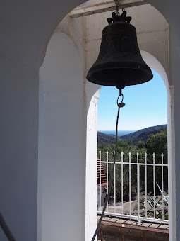
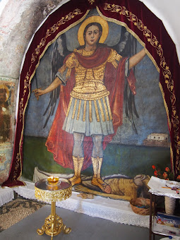
There is a final steep ascent to where an archway marks the entrance of the monastery. One has to look back at the panorama before entering, it is a awesome sight without a doubt with views all the way down to the coast and hills covered in varying shades of pine trees. The monastery door is usually locked but there is a key on a hook above the door handle although one should make sure the door is promptly shut after entering to keep the goats out. The interior to the monastery Chapel and its accompanying courtyard certainly provide a sense of satisfaction for the humble visitor who has made this pilgrimage. The Chapel is decorated with outstanding array of icons and frescos of the apostles and the Mary and Child. The highlight is a large fresco covering the height of the wall and depicting the Archangel Michael vanquishing the devil. Adjacent to the chapel is a bell tower with two bells above each other. A courtyard, decorated in black and white pebbles in an assortment of patterns, is surrounded by what used to be the monks cells and at the far end there are tables and chairs waiting for the next celebration. On this occasion there was not a soul around. Silence apart from the breezes. This really is a peaceful retreat and somewhere one can take a rest, take stock and silently contemplate. The main feature to this article is dedicated to this monastery so please read this for more details about its history and folklore.
One returns back down the mountain the same way one came up. There is an alternative route that proceeds beyond the monastery and heads down to the Skoutoularis Gorge but this is not easy to find although I have added in the GPX route on ViewRanger for those who would like to try this. Another day this is something I would certainly like to attempt and it would appear that other walkers had taken this choice judging by a couple of cars that had been parked down by the river crossing.
It is at this crossing that one can take a short excursion into the gorge which is obvious even from this point. Let ones eye follow the river course and there are sheer cliffs as it heads into the mountain. Colossal cliffs. Paths lead into this gorge and the enormity of it becomes even more real as one enters. It is a natural wonder that mere water has carved this route from solid rock over the millennia. The gorge bends round, every inch of it bringing new wonder and amazement. It is easy walking through to some huge boulders at which point the path snakes around them and then becomes a lot rougher. It certainly is dramatic and well worth the effort of wandering into its confines.
Back down at the Agios Georgios Lorima chapel decisions have to be made. One can either return back to Massari or take an alternative route and follow the old National Road through to the Italian bridge. This is something of an iconic sight and certainly one that triggers questions of its location from those who view the photos of the expedition. Personally, I think the monastery is far more worthy of recognition. The bridge can be seen in the distance from the main road. It is quite a distance from the Chapel down a long straight road. Maybe it isn't really too far but it is just the fact that long straight roads always appear a lot longer to walk than winding country lanes. There is a little chapel half way along this road, adjacent to a small cliff. Gates locked. The foot of the cliff was littered with hundreds of spent rifle shells. Masses of the things. A Stop sign at the nearby road crossing was similarly battered with bullet holes and spent shells covering the ground. It may send a shiver down ones spine to witness such articles with the nagging thought that one may be in a firing line. But reason pervades, this area was probably used in recent military exercises. Thankfully, so I am told, when such exercises are in operation the public are prevented from access. The soldiers have now gone. One is safe to freely roam.
Just prior to the bridge is a track up to another monastery, Moni Panagia set up in the hills. This is something for another day. Maybe search out a track that will take one through to Lardos or Kalathos on another days expedition and more exploring. So much to see and to do! For now one wanders across the bridge and gazes up the valley. The bridge is a huge brightly painted concrete monolith with a large arched construction towering above the road. There is probably a more succinct description but I am no bridge expert so will stick with this description for the benefit of other folk who are not bridge enthusiasts. It was obviously constructed during the period of Italian occupation of the island but I can find little else about its history.
Another straight road leads down to the main road. On the left are olive groves and a couple of ruined buildings. Old shepherd huts? Who knows? At the main road is easy to cast aside the idea of further walking and just wander down the roadside into Kalathos but I would advise against this as it is a very busy road and although there is plenty of space along the verge it does not make a conducive walk with the amount of traffic that uses this highway. The alternative is to follow a track down to a track that then leads into Kalathos

Directions
From Massari the route heads up to Moni Kammeri, returning back down this road then on to the Italian bridge and Kalathos. This route can be found on the ViewRanger app. For more information on navigation aid see theMaps and Navigation page on this site.
If starting from the main road, take the road into the centre of Massari. At the square, turn left and follow this road out of Massari. Where the road bends around to the left there is a track on the right through the orange groves with a wire fence on the left. At the crossing of another track, turn right and follow this ignoring all side tracks. It immediately goes through a double bend with tracks leading off in both directions. Go straight ahead at all other junctions following a more or less straight direction. Eventually the track merges onto another track from the right. Ignore the tracks forking off on the left and the track that goes straight ahead. Merge onto the main track which soon leads out onto the road. Turn right and follow the road, across a bridge and onto a bend where the small chapel of Agios Georgios Lorima sits. To the right a road leads up the valley beside the river bed.
Follow the river valley road as it gently curves around to the left. Keep to this road until one sees the concrete remains of what looks like a dam or bridge. Soon after this the road turns sharply tot he right and crosses the river bed, the road turning into a track. The road now heads away from the river, soon turning back to a macadam surface as it twists and turns, slowly ascending up the hills. There are various viewing points with panoramas throughout the ascent. A final steep climb takes the road to the entrance arch of Moni Kammeri.
Return back down the mountain road to just before the river crossing. On the right a track leads down onto the river bed heading for the cliffs surrounding the gorge in the near distance. Take this and keep following it, keeping to the river bed course. There are numerous tracks and paths going in this direction, take the easiest as they all head into the gorge. The river path follows the gorge as it turns around to the right. One can investigate this up the river as far as one cares to go. The initial gorge is the most spectacular and just beyond this there are some large boulders which the path goes past and continues on a much rougher surface.
Return back along the river bed, then follow the road back down to the chapel and the road junction. Turn right and follow the long straight road. Eventually it turns a sharp left, then crosses the iconic Italian bridge. This is followed by another long straight route down to the main road. Cross the main road, turning right towards Kalathos. In a short distance there is a track on the left. Take this down to a crossing of tracks. Turn right. The track bends round to the left, soon after there is a turning on the right. Take this ignoring all other tracks. Eventually there is a track on the left just before the road bends to the left with another track leading straight on. Taking the track straight ahead. Turn right at its junction with the road and continue up to the main road. The bus stop is at the junction.

Refreshments
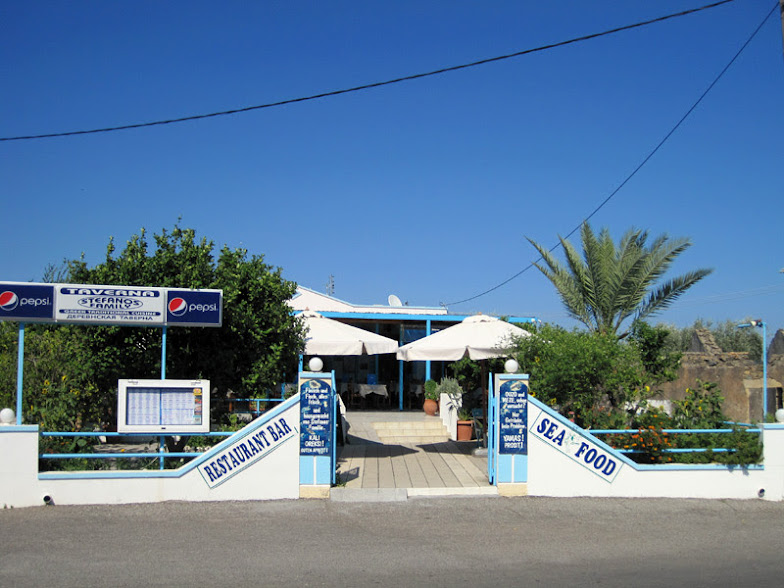
Stefanos Taverna View in Google Map
- Address
- Stefanos Taverna
Family run taverna specialising in fresh fish and seafood.
Meze and beer just the ticket after a days walking. The calamari was very good, some of the best I have ever had plus they serve the locally brewed Knights beer here.

Features
Moni KammiriView in Google Map
Moni Kammiri, or the Monastery of the Virgin Kamiriotisso, is located in the hills above the village of Massari. Its location presents magnificent panoramic views of the valley down to the coast, perfect for the peaceful and serene setting, and a worthy pilgrimage for those prepared to make the trek. One can sit in the courtyard in sweet meditation in such surroundings. Indeed, it is worth taking time out to sit, admire and contemplate such is the solemnity of the place.
It is unclear when the monastery was founded but it is thought to date from the Byzantine era, possibly the 12th century. Although thus far unsubstantiated by an academic source, there is a youtube video that claims the monastery was mentioned in the will of the Abbott Nilos of the Artamiti Monastery at Apollona in 1181. Unfortunately the source of this and other claims of its history are not provided. Nonetheless it is worth watching the video for its views of the monastery.
The present day site includes a domed Byzantine church constructed in the shape of a cross. The interior is decorated with gilded and copper painted icons along with sixteenth-century frescos of the evangelists, the largest being that of the Archangel Michael clad in a suit of armour and standing atop a vanquished body which one assumes to be the devil.
A local legend that has been handed down from mother to daughter through countless generations tells that the fresco covers up an older original painting of the Archangel Michael. The original was said to have shown such a fearsome representation of the saint that it scared a pregnant woman to such an extent that she lost the baby. Other pregnant women were also said to have suffered the same outcome and the decision was taken to cover it with a more endearing image which survives to this day.
In front of the church is a courtyard, paved with black and white pebbles that decorate the floor with various patterns. The courtyard is bordered by a series of old monks cells and an outdoor hearth surmounted by a beam of sculpted marble. At the far end is a shaded terrace provides shelter and seats sit ready for the festive days when food and retsina run liberally in celebration, such as the presentation of the Virgin Mary which occurs each year on the 12 July.
Another legend that surrounds the area, although I have yet to find additional confirmation of this, is that of a battle between Turks and Rhodian rebels that took place in the nearby ravine on 12th February 1579. Presumably the ravine is part of the Skoutoularis Gorges through which the river flows. The rebels were outnumbered by 600 to 80 and the battle left 147 dead although nothing is stated about the sides which suffered the most casualties. It is said the restless spirits of those warriors still roam the area.
References

Gallery
Below are a selection of images taken from from the photo album for this walk. Feel free to browse through these or click on an image to view a larger version in the Gallery.


Summary of Document Changes
Last Updated: 2021-12-07


0 comments:
Post a Comment